For those of you using GNSS surveying or mapping systems in Oregon or Washington, you have access to real time correctors via cellular modem or cell phone to a comprehensive network of GNSS base stations, providing there is cellular service somewhere near your project site.
VRS Information
A VRS, or Virtual Reference Station, is a network of GNSS base stations, all sending their data to a single computer, each second, 24 hours per day, 7 days per week. That computer is connected to the Internet which allows users to access this data. If the user can connect to the Internet while in the field, they can receive the data stream which will apply real time corrections to whatever level of accuracy the GNSS system can produce.
For instance, a Trimble GeoXT 6000 or Geo7X can achieve 50cm accuracy in real time. A Trimble GeoXH 6000 or Geo7X, H-Star can achieve 10cm in real time. A Trimble GeoXH 6000 Centimeter Edition or Geo7X Centimeter Kit and achieve 1cm in real time. A survey-grade RTK system can achieve 1cm as well.
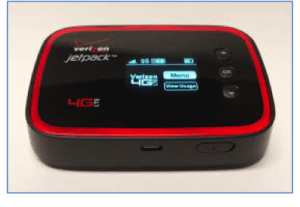
So how can a user connect to the Internet while in the field? A cellular modem, cell phone or portable “hotspot” are the best options. The newer GNSS mapping systems can be purchased with a cellular modem built into the hardware. With some units, it’s an option, while with others it’s included in the price of the unit. Another option is to use your cell phone. If you have a smart phone that has a “hotspot” feature and you are subscribed to a data plan, you can connect to the Internet. The last option is to purchase a portable hotspot which is typically a little box that picks up a cell signal and re-broadcasts Wi-Fi. You then use the Wi-Fi capability of your GNSS receiver to complete the connection to the Internet. (Verizon 4G-LTE JetPack shown)
You must use field data collection software that supports the connection to the Internet as a source of real time corrections. Examples are TerraSync Professional or TerraSync Centimeter Edition, ArcPad with Trimble Positions, or ArcGIS Mobile with Trimble Positions. Other manufacturers may have programs that support this type of connection as well.
Washington – Oregon VRS
The real time settings in the setup menu of the field data collection software is the point at which most questions arise. Once you have all the necessary information entered: the VRS datum, the IP address of the server and the Port number, you will see a server table. Which one do you choose?
The State of Washington offers approximately 100 stations from which to choose. In addition, there are “subnets,” or smaller groups of base stations that act as a miniature VRS. These subnets geographically surround a particular area of the state. An example of this is the Puget Sound Subnet. If you are working anywhere in the Puget Sound area, you will be working inside this subnet. This means you have the option to either connect to this network of base stations (VRS), or to a single base.
The advantage to connecting to a subnet is that you are receiving a network adjusted solution which will often be more accurate than a single base solution. In addition, when using a subnet, it doesn’t matter how far away you are from any particular base station in that system. As long as you are geographically inside that network, you will get an excellent solution.
However, if you are using a single base, it matters very much how far away you are from that base station. Recommended distances vary depending on the accuracy capabilities of your GNSS receiver and the accuracy you are trying achieve.
When using a centimeter system, you must be no farther away than 30Km from the base. For a decimeter unit, you must be no farther than 80Km from the base. When using a submeter unit, you must be no farther than 250Km from the base.
So you can see that these distances don’t have to be considered when connecting to a network of base stations vs. a single base. Here’s a map of base stations available in Washington:
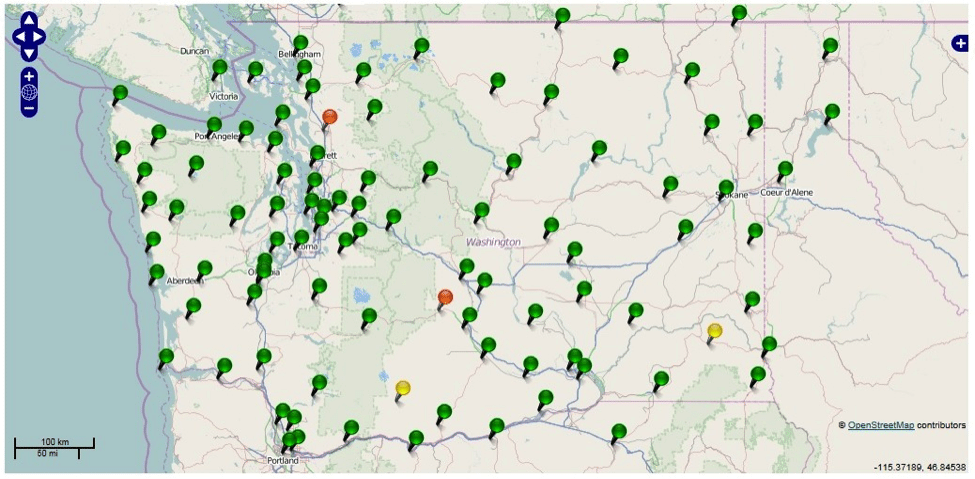
To effectively achieve accurate survey control in any geographic area, it’s important to establish control points outside that area whenever possible. Notice that there are base stations in Idaho and Oregon and at the Canadian border which provide excellent coverage for the entire state of Washington.
The WSRN (Washington State Realtime Network) is fully mature and most stations are broadcasting and storing GPS-GLONASS data. WSRN: http://www.wsrn3.org/
Here’s a map of base stations available in Oregon:
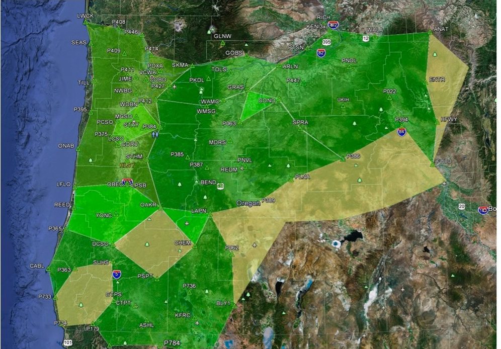
You’ll notice that the entire state is not yet covered. The ORGN (Oregon Realtime GPS Network) is not yet complete, but more stations will be added as time passes. ORGN: http://www.oregon.gov/ODOT/HWY/theorgn/Pages/Theorgn-Home.aspx
This document will explain how to choose your single base or VRS subnet when using Trimble TerraSync or Trimble Positions software. Both programs support the connection to real time correctors providing it is also supported by the GNSS receiver you are using. Note: SiRF receivers are not supported. http://en.wikipedia.org/wiki/SiR
SiRF receivers are built into the Trimble Juno3 Series, Nomad 900 Series and Yuma Series.
Information about the WSRN & ORGN
Washington
The State of Washington has created several Subnets throughout the state. You can choose the subnet from which to receive corrections based on your location within the state. Here’s a map of the entire network and the subnets.
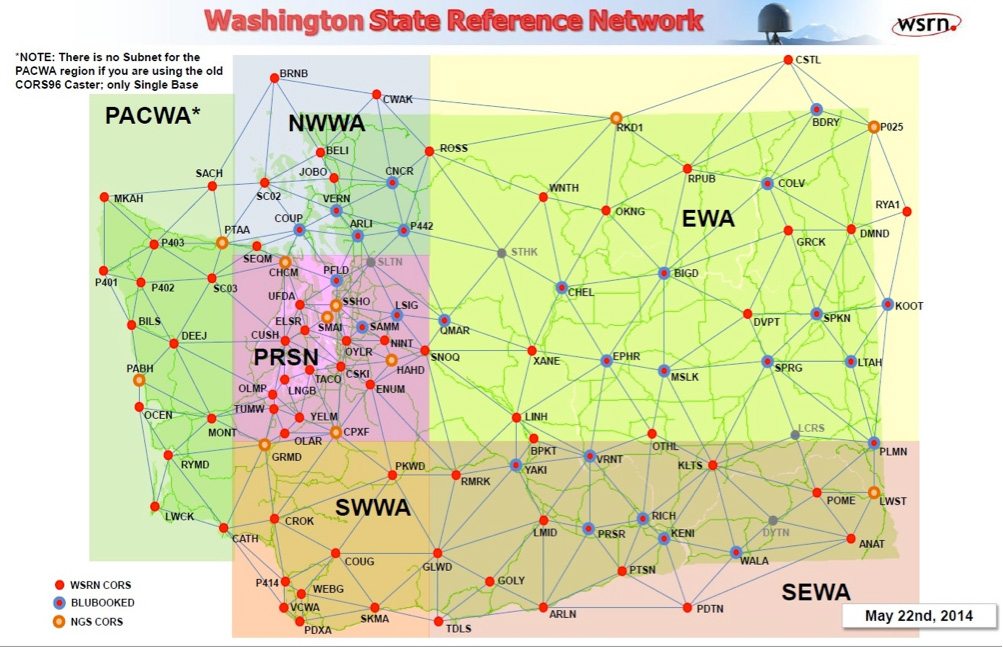
There are 5 subnets; Northwest Washington (NWWA), Puget Sound Network (PRSN), Southwestern Washington (SWWA), Eastern Washington (EWA) and Southeast Washington (SEWA). The PACWA is not a subnet. In that region you can only connect to a single base.
To effectively use these subnets, you must be within that region. Using a subnet will result in getting correctors from multiple stations providing the user with a network adjusted solution in real time.
Most Washington base stations have been upgraded to receive GLONASS satellites so for those with multi-constellation GNSS receivers, you can take full advantage of either a single base or subnet (VRS) to receive correctors on all the satellites your GLONASS receiver is using.
Oregon
The Oregon Realtime GPS Network is comprised of approximately 80 base stations, some of which are also collecting GLONASS data. Most are collecting only GPS data. For those using multi-constellation receivers, it is advisable to connect to a single base station that is collecting both GPS and GLONASS data. This will enable you to take full advantage of the capabilities of your system.
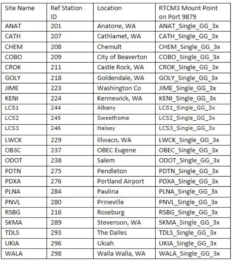
Here’s a current list of the multi-constellation base stations in Oregon:
You will notice that some of the Oregon base stations are located in the State of Washington just as some of the Washington stations are located in Oregon.
In Oregon, you don’t select a pre-defined subnet from the server list. You select an IMAX corrector. That is defined as a GPS-only group of base stations that are selected for you, based on your location within the state. In order obtain corrections from both GPS and GLONASS satellites, you must connect from one of the single base locations above.
Reminder: If you are considering using one of these stations from which to receive real time corrections, you must be within 30Km (18.6 miles) to achieve 1cm accuracy; 80Km (49.6 miles) to achieve 10cm accuracy; 250Km (155 miles) to achieve 50cm accuracy.
Connecting to the Network
In either TerraSync or Trimble Positions, go to Setup, then Real Time Settings. Change Uncorrected GNSS to External Source. Tap the wrench. The first selection you must make is the Correction Datum:
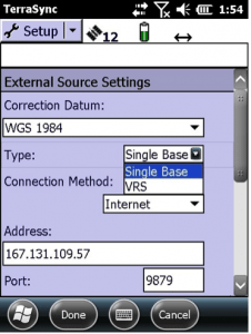
The real time data stream is broadcasting WGS 1984. Under Type, you must decide if you are connecting to a Single Base or a VRS. A VRS is most desirable, but you may connect to a single base keeping your distanced from that base in mind.
Next, you must select Internet as the Connection Method. The software will provide you with a field in which to enter the IP address of the computer that’s serving up the correction data.
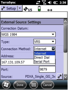
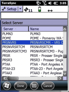
Enter the IP address of the computer. Enter the Port number over which the data will be streamed. If you are successfully connected the Internet, a server table will appear. You can alphabetize that table by name, the scroll to the single base or subnet name you would like to use.
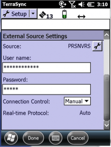
In the following example the user has selected the Puget Sound Subnet with the designation PRSNVRS. The letters denote that it’s a Puget Sound region subnet server providing corrections from multiple base stations.
All you have left to do is enter your login and password. You can choose either Auto or Manual for Connection Control. We prefer Manual because sometimes it takes more time to acquire satellites than anticipated. The attempt to connect to the real time correctors can time out before the receiver has enough satellites for a position. Once there are enough satellites, you can manually connect to the real time source.
You can tap Done and then again, Done. Your GNSS unit is now receiving real time corrections from the server you chose.
Check Real Time Observations with Survey Control Points
Once you are receiving real time corrections, it’s important that in TerraSync, you go to the Coordinate System menu. Select the coordinate system, datum, zone, altitude reference, Geoid model and units. You MUST know exactly what to choose in all the drop-down menus in order to display coordinates according to the spatial reference in which you wish to work.
TerraSync collects and stores all field data in terms of Latitude, Longitude, and Altitude HAE in meters. When you make the changes described above, TerraSync is transforming the data to the spatial reference you selected.
Once you have selected the spatial reference, you should go to a survey control monument, hold the GNSS antenna over the point, collect some data, and then compare the published coordinates of that location to the observed coordinates produced by your GNSS mapping system.
If the published coordinates of the survey control point are different than the spatial reference you chose, you can change the display settings by going back to Setup, the Coordinate System menu and make the necessary changes.
It’s very important to confirm that your system is producing the accuracy you expect.
This process of observing on a known survey monument accomplished several things:
- Did you pick the correct single base or subnet for corrections?
- Did you use the correct settings in the Real Time Settings/External Source menu?
- Did you select the correct display settings in the Coordinate System menu?
- Did you hold the antenna properly over the point when you collected data?
If you are using ArcPad or ArcGIS Mobile with Trimble Positions, you can use this same check against a survey control monument. However, those programs do not provide the same flexibility in changing the spatial reference in the field. In this case, you can check accuracy by comparing the Latitude, Longitude coordinates which are also printed on the control point datasheet.
Here’s a good source of survey control points established by the National Geodetic Survey (NGS).
http://www.ngs.noaa.gov/cgi-bin/ds_radius.prl
How Much Does it Cost?
The ORGN is free of charge. They provide the data stream at no cost. You do have to provide the connection to the Internet and may incur charges to your cell phone carrier depending on the data plan you choose. You can get a data plan with a built-in modem on the GNSS unit, your cell phone, or a portable hotspot.
The WSRN is free of charge for 90 days as a test period to insure that it works in your project area and that it is providing the corrections you require. After that, the price is $1900 per year, per receiver.
Contacts
Contact for the WSRN:
Gavin Schrock – State of Washington
Seattle Public Utilities
700 5th Ave
Suite 4900
PO Box 34018
Seattle, WA 98124
(206)684-5630 office
(206)684-7396 fax
gavin.schrock@seattle.gov
Contact for the ORGN:
Ken Bays
Geodetic Control Specialist
OR Dept. of Transportation
4040 Fairview Industrial Drive SE, MS#4
Salem, OR 97302
(503)986-3543 office
(503)986-3548 fax
kenneth.bays@odot.state.or.us
Summary
There are many more details involved in using high-accuracy, real time networks. For that reason we have not covered every subject here. If you have any questions, please contact us. We will be happy to help you.
Solutions
Frontier Precision provides world-class solutions for a wide variety of industries using leading products, training, technical services and more.


Products
Technical Services
If you require customized technical services and training, please contact Frontier Precision at 800-359-3703 or reach out to a local Frontier Precision location.
Training and Events
Frontier Precision offers affordable regularly scheduled certified training classes, online eLearning, webinars, as well as custom training options to meet your specific training needs.
About Frontier Precision
Contact Frontier Precision
