Maybe we always say this, but there’s a lot of great new stuff in this release and we’re excited about it! Where do we start?
Required Weather Entry
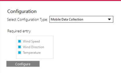
Let’s start with a relatively minor change that several of our customers asked about. Many states require weather info to be part of the treatment record, so now you can require that weather data be entered on the Mobile side. This is set on the Office side in Configuration > Mobile Data Collection. Wind Speed, Wind Direction, and Temperature can each be set to required entry. When the user creates a spray session in the field, they will have to fill in this info. If you’re using an AirMar weather station on the truck, this will be filled in automatically from the connected weather station. Otherwise, just enter valid data from whatever source you trust, and now the weather info is part of the permanent record.
Automatic Data Extraction
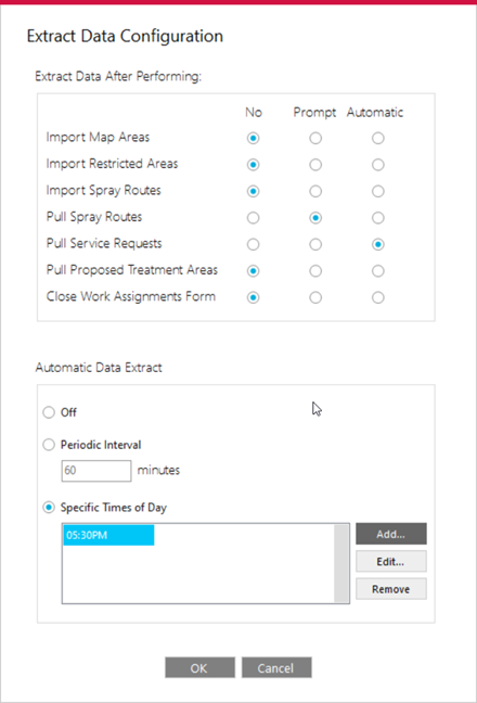
Next up, we have a more extensive set of changes also requested by some customers and our support group related to automatic data extraction. There are so many different ways that important data can be entered into the system, whether it’s restricted areas, spray routes, service requests, zones, or other system changes, including manual changes, importing shapefiles, or syncing data from ArcGIS Online. It’s usually crucial that these changes be included in the dataset the field operators are using on the Mobile side.
So, we’ve added configuration options to either prompt the user to do a data extract from the Office side, or automatically do it. The Mobile user will still have to Sync when they start the software to get the changes, but at least if that is always done prior to new missions, the data will always be up to date in the field.
Extract can be triggered whenever new data is imported from shapefiles or pulled from ArcGIS Online, or when the Work Assignments form is closed. Additionally, extract can be set to run automatically at specific times of day or on a periodic interval.
We hope this will help ensure that field data is always up to date.
Restricted Area Integration with ArcGIS Online
This is one that customers, and support, have been waiting on. We could always create restricted areas in the Office program, and we could import shapefiles, but now we can also sync the Restricted Area layer with ArcGIS Online. This means that if you’re using FieldSeeker Core and you want to have one Restricted Area layer used by both programs, you can now keep the data in sync.
We added a configuration screen to set it up.
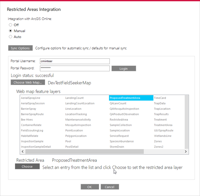
Once enabled, sync options can be configured (in the layer list). The process is flexible to support different business processes for managing restricted areas. You can enable push and pull independently, set options for each, and choose the order in which these occur.
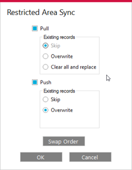
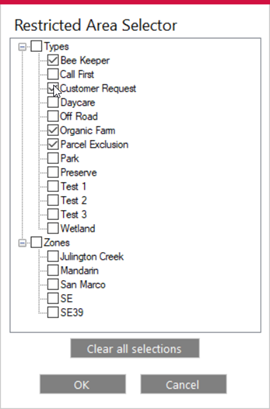
After Restricted Areas are in the map, you can set display filters for which ones to show – that way, you can hide any that don’t apply to adult control, for example.
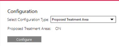
Proposed Treatment Area Integration with ArcGIS Online
We also added a new layer called Proposed Treatment Area to support the fact that some customers have zones, which they use Map Areas for, and they also want to be able to sketch in treatment polygons. If you wish to enable the Proposed Treatment Area layer, you can turn it on in Configuration. By default this is not turned on, because many customers may not be interested.
FieldSeeker Core already had a similar notion of planned treatment polygons, so we also added the ability to sync this data with ArcGIS Online. You can choose the map and layer to sync with, which is pretty easy if you’re using Core – it’s the ProposedTreatmentArea layer.
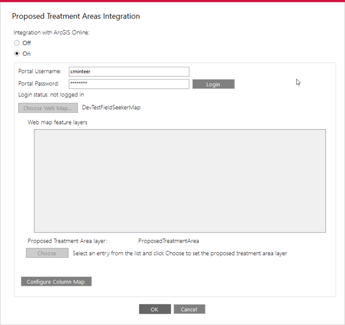
But, for those customers that are using other Esri ArcGIS Online based workflows for planned treatment polygons, we also added the ability to set up column mapping to match up the data from those systems with our FieldSeeker data. So that’s what the Configure Column Map option lets you set up.

Once enabled, sync options can be configured (in the layer list). The process is flexible to support different business processes for managing restricted areas. You can enable push and pull independently, set options for each, and choose the order in which these occur.
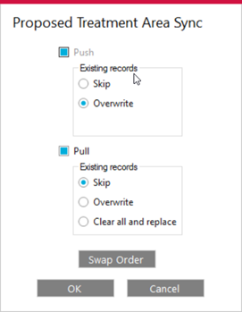
And after the data is in your map, you can also filter feature display.

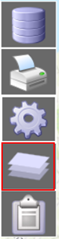
Refactor Layers GUI
We’ve added just enough new layers into the program that the previous user interface of buttons along the bottom of the map wasn’t working anymore. So, now we have a Layers dialog. Hopefully, not too much like GIS! But, the display was starting to look a bit cluttered so we made a decision, and user feedback tells us that if you’ve used Google Earth or any web-based mapping program, the Layers button is pretty universally understood.
Some layers will only show up if those options are enabled – we wanted to also keep the user interface simple if you’re just starting to use the program and all you want to do is track, record, and report.
Assignments
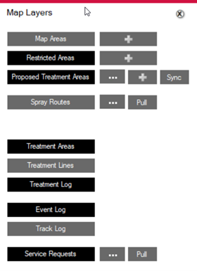
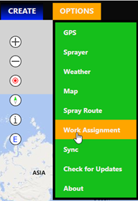
Lastly, we come to a big new addition to the program – assignments. Supervisors can now assign Spray Routes or Proposed Treatment Areas to drivers. If you wish to use this option, you can turn on Work Assignments in configuration, and a new tool will show up in the toolbar on the left of the map screen.

The top list will show all unassigned routes and proposed treatment areas, and the bottom will show all uncompleted assignments.

Click on any column header to sort the data by Map Area, Priority, Method, Due Date, Assigned To, Scheduled Date, etc.

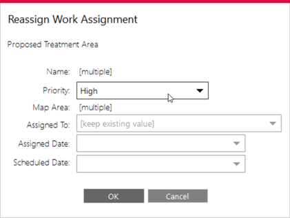
Select one or more features and click Create Assignments. While assigning the routes or proposed treatment areas, you can set the Priority, Assigned To, Assigned Date (defaults to the current date), and Scheduled Date.

After assignments are made, you can edit or reassign them. For example, if someone is out sick, you can select their assignments and reassign them to someone else, or if there is bad weather, you can change the scheduled date. You can also delete an assignment.
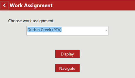
You can complete assignments from the Office, but the normal flow would be for the driver to log in, view assignments, and complete them by recording spray sessions.
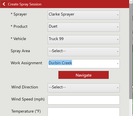
Then the user finishes the spray session, they will be prompted whether the assignment is completed. If they click yes, then the assignment is marked complete; if no, then they can do another spray session and select the same assignment to complete.
When the field data is processed, the assignment will show as completed on the Office side. Details about when it was completed and by whom will be filled in on the Proposed Treatment Area, if that’s what the assignment is based on, and those details can be pushed back to ArcGIS Online, if that’s how sync options are set up.
Other Improvements
There are a few other minor improvements as well. We added a delete option to the Service Request popup. The extracted data geopackage file is not removed until a successful extract (we had some support issues where the extract did not complete for whatever reason, and then after syncing, the mobile device didn’t have a geopackage file to use and it wouldn’t let users log in.) We updated Crystal Reports to 32-bit 13.0.19. And we fixed a bunch of other things large and small, some of which you won’t see. Here’s our Release Notes for full details.
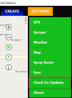
How to Get the New Version
To make support updates and the delivery of new features easier for us and for you, we built auto-update into both the ULV Office and ULV Mobile software. If you already have the software installed, simply Check for Updates.
![]()
If you are interested in seeing a demo or purchasing the software, Contact us today for information and pricing.
See our Software Roadmap for more details.
If you have questions, please contact us.
What’s New in v2.1 FieldSeeker Windows ULV – March 2021 Video
See our Software Roadmap for more details.
If you have questions, please contact us.
Linda Glover, Sales Manager, (208) 324-8006
Chad Minteer, Product Manager, (208) 595-1435
Tyler McGarrity or Chris McCabe, Technical Support and Account Management, mosquitosupport@frontierprecision.com, (208) 324-8006
Solutions
Frontier Precision provides world-class solutions for a wide variety of industries using leading products, training, technical services and more.


Products
Technical Services
If you require customized technical services and training, please contact Frontier Precision at 800-359-3703 or reach out to a local Frontier Precision location.
Training and Events
Frontier Precision offers affordable regularly scheduled certified training classes, online eLearning, webinars, as well as custom training options to meet your specific training needs.
About Frontier Precision
Contact Frontier Precision
