Using Trimble’s R1 to Achieve Professional Accuracy in Esri’s Collector App
What is Esri’s Collector App?
Collector for ArcGIS is a data collection app for iOS and Android devices that integrates seamlessly with your ArcGIS Online account to collect and update data hosted in the cloud or on your server. Collector is becoming more and more popular as a solution for the BYOD users. The recent addition of support for related tables make it an ideal solution for asset inspection and maintenance.
Why use the Trimble R1?
One of the most common concerns when using a phone or tablet for data collection is accuracy. In February 2015, Trimble released the R1 GNSS receiver, a small, rugged receiver that works with iOS, Android or Windows Mobile handhelds. This receiver achieves professional-grade accuracy and allows users to transform their consumer devices into higher accuracy data collection systems.
What level of accuracy can I expect when pairing the R1 with Collector?
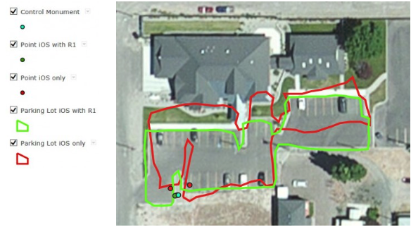
As you will see in the video below, Collector will not display an estimated accuracy of less than 5 meters. Esri has indicated that better support for high accuracy receivers in Collector is coming, but for now, it will never display better than 5 meters. This does not mean that you cannot achieve accuracy around 1 meter with the R1, only that the display will never show better than 5 meters. The tests below show the difference between using an iPhone’s internal GPS vs. using a phone or tablet connected to an R1. In the map below, the iOS-only data is shown in red. The iOS connected to an R1 receiver with SBAS connection is shown in green. The control monument for point testing is shown in blue.

In the table below, the Actual Nothing and Easting represent the control monument. Four positions were collected at the control; two with the R1 and 2 without.

How do I connect the R1 to my iOS device for use in Collector?
Getting your iOS device connected to an R1 through Bluetooth may seem intimidating, but it can be achieved through a few simple steps.
- Download the Collector for ArcGIS app and Trimble GNSS Status Utility off of the app store. Both of these apps will be free to download.
- Connect the R1 receiver to you iOS device with Bluetooth. On the R1, push and hold the power button until the left LED light flashes blue. On your iOS device go to Settings>Bluetooth and turn Bluetooth on. The R1 should now show in your Devices list as GNSS:<last five digits of the R1 serial number>. Tap on the R1 in the Device list to connect.
- Open the GNSS Status Utility. If necessary, tap on No Receiver Connected. Select the R1 and tap on the plugs to establish the connection.
- If you are interested in using the SBAS corrections for higher accuracy, you will need to set it in the GNSS Status Utility. Tap Menu to bring up your options and go to Real-time Config. Edit the setting to change it to SBAS. Now, if you go to the Home screen, you should start to see your accuracy decrease as it connects to the SBAS satellite correction. If you want to see the SBAS satellites you are currently tracking, go to Detailed Status in the Menu. You will see a satellite count under Satellites by System.
- The GNSS Status Utility automatically creates a mock location for Collector to use. When you open the Collector app, it should be connected to the R1 and no settings have to be changed. If you want to test that you are connected to the R1, set it on the ground and walk away with your iOS device. Your position in Collector should stay stationary as you move.
The comparison map is available for you to take a closer look on our ArcGIS Online Home Page. While you’re there, check out other exciting applications for ArcGIS Online and Collector.


