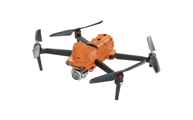
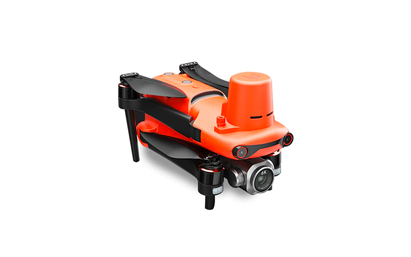
Description
Centimeter-level Positioning
• RTK Horizontal Positioning | Accuracy: 1cm+1ppm
• RTK Vertical Positioning | Accuracy: 1.5cm+1ppm
No GCP Required
EVO II RTK Series V3 can connect to an NTRIP network and does not need GCPs to provide centimeter-grade accuracy.
3rd Party Base Station Support
EVO II RTK Series V3 supports all NTRIP-compatible base stations.
Autel Explorer for Mapping
• Multi-NTRIP Profile Saving: For repeatable data acquisition missions, you can record the drone’s previous shooting positions. All the gimbals, camera, and aircraft movements will be replicated, thus producing a full record of the entire mission.
• Photo Replication: For repeatable missions, you can record the drone’s previous shooting parameters. The gimbal, camera, and movement settings will be replicated, allowing missions to be easily duplicated.
• Multi-battery Missions: The Explorer app allows the user to create and save multiple NTRIP profiles for different locations, so they don’t have to manually input a new flight for every new location.
Capture Every Detail
The EVO II Pro RTK V3 has high dynamic range and powerful low light performance, enabling users to capture clear detail sets with minimal distortion and noise.
• 1-inch Ultra-sensitive Sensor: comes with a NEW updated 1-inch 6K CMOS image sensor with a maximum of 20 megapixels. Thanks to the ultra-sensitive algorithm, you can still shoot clean, detailed, low-noise data sets under twilight or night conditions.
• f/2.8 ~ f/11 Adjustable Aperture: adapt to lighting changes by adjusting the lens aperture size, giving the pilot more shutter speed control.
• Zoom in for the Details: optimized datasets to be easily adjusted with post processing software applications
• Optimized for Software Image Correction: optimized datasets to be easily adjusted with post processing software applications
360° Obstacle Avoidance
Equipped with 19 groups of sensors including 12 visual sensors, the main camera, ultrasound, IMUs, and other sensors to enable the building of three-dimensional maps and path planning in real time.
*Please refer to the manual for details on obstacle avoidance and its limitations, which may or may not work in limited lighting environments, under direct, strong sunlight, or across thin tree branches or wires.
Autel SkyLink 2.0 Video Transmission
SkyLink 2.0 is built into the EVO II V3 chipset, expanding the possibilities for your most critical workflows.
• 9+ Miles | Do more because you can fly further away
• QHD | Incredible video resolution within a mile, meeting most common use cases
• 2.4GHz / 5.8GHz / 900MHz | Supports tri-band communication with automatic frequency hopping for maximum anti-interference capabilities (900MHz is only applicable for FCC countries)
Portable and Easy to Use
• Compact Design: folds up for ease of transport and deployment
• Trouble Free Daily Workflows: takes 45 seconds from setup to takeoff
• 27mph Max Wind Resistance: smaller cross section and powerful motors allow greater stability and control in all windy conditions
• 38 Minute Flight Time: enjoy up to 38 minutes of flight time – 20% ~ 30% more than the next leading competitor for more area coverage and longer missions
• No Fly Zones*: does not have any no fly zones and will not prevent the pilot from taking off
• No Forced Updates**: does not need to be on the latest hardware or app version in order to takeoff unlike other competitors
*Please fly safely and consult your local laws and regulations. Autel Robotics and Frontier Precision is not liable for any unauthorized flights.
**It’s required to update to the latest firmware and app to enjoy comprehensive warranty. For more information, please refer to the warranty policy.
Autel Smart Controller SE
The Smart Controller SE comes with a 6.4-inch OLED touch screen and latest gen. 8-core processor for HD image transmission. SkyLink 2.0 Transmission technology guarantees long-distance operations from up to 15km away and enhances anti-interference abilities with tri-band frequency hopping. The customized Android system allows for additional flexibility with 3rd party apps and an IP43 rating that ensures all weather performance.
• 6.4-inch OLED Screen
• 15km Transmission Range
• Removable battery
• 3rd Party Apps
• -10° to 40°C Operating Temperature
Broadcast with Live Deck 2
Transmit real-time HD video to a wide variety of devices, allowing cross departmental teams enhanced situational awareness and communication, which can lead to quicker and better decision making (supported on all EVO II V3 drones).
• 1080P / 60fps Video Stream
• 7.5 Mile Transmission Range
• Three Auto-switch Bands
• IP43 Resistance
Solutions
Frontier Precision provides world-class solutions for a wide variety of industries using leading products, training, technical services and more.
Products
Frontier Precision knows that every measurement its customers take is important. It’s why Frontier Precision not only offers the latest, cutting-edge measurement tools, but also understand the continuing need for service and support — because How You Measure Matters encompasses the total customer experience.
● Used & Clearance Equipment
● Rental Equipment
● Drones/UAS Aircraft
● Underwater ROV’s & Robots
● Survey
● Mapping & GIS
● Damage Prevention & Locating Devices
● Mosquito & Vector Control Software
● Invasive Plant Control Software
● Monitoring
● Scanning/Imaging
● Construction
● Augmented Reality
● Mixed Reality
● Forensics
● Water Resources
● Software
Technical Services
From Geospatial Services to GIS Professional Services to Water Resources Data Acquisition Services, Frontier Precision delivers leading-edge measurement technology. We’ve been there, every centimeter of the way, as geospatial technology has evolved. No matter what your need for accurate measurement, we have the experience and expertise to create a customized solution for you.
● Water Resources Data Acquisition Services
If you require customized technical services and training, please contact Frontier Precision at 800-359-3703 or reach out to a local Frontier Precision location.
Training and Events
From Geospatial Services to GIS Professional Services to Water Resources Data Acquisition Services, Frontier Precision delivers leading-edge measurement technology. We’ve been there, every centimeter of the way, as geospatial technology has evolved. No matter what your need for accurate measurement, we have the experience and expertise to create a customized solution for you.
- Technical Training & Events Calendar
- Technology Webinars
- Customized Training Request
- On-Demand Training
- Learning Lab
Frontier Precision offers affordable regularly scheduled certified training classes, online eLearning, webinars, as well as custom training options to meet your specific training needs.
Support
Frontier Precision provides world-class support from centers across a wide section of the western United States. Need support for any geospatial products, software or services?
Contact Frontier Precision at 800-359-3703.
About Frontier Precision
Frontier Precision’s measure of excellence can be traced back to 1988. Four years later, in 1991, Frontier Precision partnered with Trimble — a United States-based GPS equipment manufacturer at the time, and the rest is history. Since then, Frontier Precision has grown with Trimble to be one their largest and best geospatial distributors in the world.
We’ve been at the frontier of technology for three decades, continually offering customers new tools and solutions, all with our end goal in mind to help make our customers efficient, productive, and profitable with today’s and tomorrow’s technology. Frontier Precision is an employee-owned company — each of our team members is committed to your success.
Contact Frontier Precision
WHEREVER YOU ARE, WE ARE.
From our original office in Bismarck, North Dakota, we’ve grown our footprint thousands of miles in every direction.Today, you’ll also find us in South Dakota, Minnesota, Colorado, Alaska, Montana, Idaho, Hawaii, Wyoming, Oregon and Washington — delivering the Frontier Precision difference to more people each day.