Description
Stabilized X32 Zoom Thermal Imagery | 4K Visual Excellence
The 32x zoom is designed around two 21-megapixel cameras, allowing operators to see details clearly from up to 2 km (1.2 mi) away.
The zoom image is coupled (blended) with images from ANAFI USA’s FLIR camera. This enables operators to detect hot spots with the thermal camera, from an altitude of up to 131 ft.
Rugged and Ready
ANAFI USA is flight ready in 55 seconds: it takes less than 55 seconds to unfold the drone, turn it on, establish the secure radio link and take off.
ANAFI USA has zero no fly zone limitation.
Made in the USA
Data Encryption
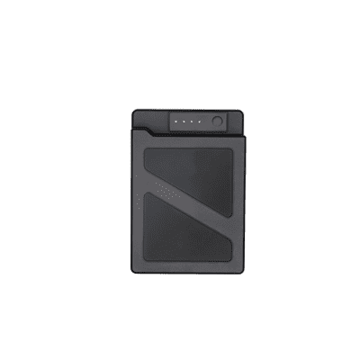
Weighing in at just 500 g (1.1lb) the compact ANAFI USA folds easily for maximum portability. Despite its compact design, ANAFI USA boasts a 32-minute flight time – also best in class for a drone of its size.
Trusted and Proven Globally
The largest Partner Ecosystem for drones.
Extend your professional usage.
Photos and videos are encrypted on its SD card, using an AES-XTS algorithm with a 512-bit key length. ANAFI USA’s Secure Digital (SD) card encryption feature ensures that saved data cannot be read if the drone or SD card is lost or stolen. Once encrypted, data can only be read with the decryption key.
ANAFI USA also includes a secure WPA2 Wi-Fi connection. WPA2 provides authentication and encryption of the link between the remote controller and ANAFI USA.
Signed firmware prevents any malicious modification of the drone software.
Users can choose to share data by opting in via the FreeFlight 6 app. No data is shared by default without the consent of the user. After opting-in to the feature, flight data and logs are stored on secure servers in Europe in addition to local copies of the data on the drone. The drone’s features are fully compliant with the European Union General Data Protection Regulation (GDPR).
Software Ecosystem
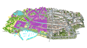
Compatible with the industry-leading mapping software Pix4Dreact, ANAFI USA allows first responders to quickly transform images into precise 2D maps on a laptop.
Through its open-source SDK and use of industry-standard protocols, ANAFI USA supports a growing ecosystem of professional applications and services, such as Survae (smart searching and visualization platform connecting video, images, and sensor data to interactive maps and timelines), DroneLogbook (compliance and fleet management), Kittyhawk (compliance and security for enterprise UAS fleet and airspace management.), DroneSense (comprehensive drone management platform enabling public safety organizations to build, manage, and scale their unmanned aircraft programs), Planck AeroSystems (autonomous landing on a moving vehicle), and Skyward, A Verizon company (aviation management platform, including airspace, LAANC access, as well as training, hardware, and connectivity for enterprise drone fleet deployments).
Part of the Robust Freeflight 6 Ecosystem, Complete with Mission-specific Features
- Powered by FreeFlight 6, ANAFI’s acclaimed piloting software
- Fly by coordinates in assisted framing or full autonomous flights: define points of interest (POI), waypoints (WP) and landing points with their satellite navigation coordinates (GPS, GLONASS, GALILEO)
- Visual tracking empowered by proprietary deep neural network and machine learning AI
- Direct onscreen reading of scene coordinates
- Drag and drop an RTH point on the map
- Interfaces easily with Pix4Dcapture & Pix4Dreact (fast offline 2D mapping) solutions
Pack Contents
- 1 ANAFI USA drone
- 3 smart batteries (3×32 minutes)
- 1 Skycontroller USA with its 8-inch display
- 1 multi-port fast USB charger
- 1 Skycontroller USA charger
- 1 additional set of propeller blades
- 3 USB-A/USB-C cables
- 1 USB-C/USB-C cable
- 1 hard case
- 1 sunvisor
- 1 neck strap
Solutions
Frontier Precision provides world-class solutions for a wide variety of industries using leading products, training, technical services and more.
Products
Frontier Precision knows that every measurement its customers take is important. It’s why Frontier Precision not only offers the latest, cutting-edge measurement tools, but also understand the continuing need for service and support — because How You Measure Matters encompasses the total customer experience.
● Used & Clearance Equipment
● Rental Equipment
● Drones/UAS Aircraft
● Underwater ROV’s & Robots
● Survey
● Mapping & GIS
● Damage Prevention & Locating Devices
● Mosquito & Vector Control Software
● Invasive Plant Control Software
● Monitoring
● Scanning/Imaging
● Construction
● Augmented Reality
● Mixed Reality
● Forensics
● Water Resources
● Software
Technical Services
From Geospatial Services to GIS Professional Services to Water Resources Data Acquisition Services, Frontier Precision delivers leading-edge measurement technology. We’ve been there, every centimeter of the way, as geospatial technology has evolved. No matter what your need for accurate measurement, we have the experience and expertise to create a customized solution for you.
● Water Resources Data Acquisition Services
If you require customized technical services and training, please contact Frontier Precision at 800-359-3703 or reach out to a local Frontier Precision location.
Training and Events
From Geospatial Services to GIS Professional Services to Water Resources Data Acquisition Services, Frontier Precision delivers leading-edge measurement technology. We’ve been there, every centimeter of the way, as geospatial technology has evolved. No matter what your need for accurate measurement, we have the experience and expertise to create a customized solution for you.
- Technical Training & Events Calendar
- Technology Webinars
- Customized Training Request
- On-Demand Training
- Learning Lab
Frontier Precision offers affordable regularly scheduled certified training classes, online eLearning, webinars, as well as custom training options to meet your specific training needs.
Support
Frontier Precision provides world-class support from centers across a wide section of the western United States. Need support for any geospatial products, software or services?
Contact Frontier Precision at 800-359-3703.
About Frontier Precision
Frontier Precision’s measure of excellence can be traced back to 1988. Four years later, in 1991, Frontier Precision partnered with Trimble — a United States-based GPS equipment manufacturer at the time, and the rest is history. Since then, Frontier Precision has grown with Trimble to be one their largest and best geospatial distributors in the world.
We’ve been at the frontier of technology for three decades, continually offering customers new tools and solutions, all with our end goal in mind to help make our customers efficient, productive, and profitable with today’s and tomorrow’s technology. Frontier Precision is an employee-owned company — each of our team members is committed to your success.
Contact Frontier Precision
WHEREVER YOU ARE, WE ARE.
From our original office in Bismarck, North Dakota, we’ve grown our footprint thousands of miles in every direction.Today, you’ll also find us in South Dakota, Minnesota, Colorado, Alaska, Montana, Idaho, Hawaii, Wyoming, Oregon and Washington — delivering the Frontier Precision difference to more people each day.