Description
Cost Effective Asset Monitoring with Senceive’s Innovative Sensor Range
Senceive’s wireless platforms address the monitoring needs of Rail, Construction, Utilities and Cities as well as Mining asset users with its innovative and easy to use, long lasting wireless solution which interfaces to a wide range of geo-technical and structural sensors.
Furthermore, it can utilize highly resilient wireless communications through mains power free/solar cellular backhaul or flexible and resilient sub surface industrial monitoring hubs and gateways. It also provides easy to use data visualization tools of its own through our own visualization software or can be linked to the customer’s own specific software.
Key Benefits
- Customisable site images / site maps for display of overlaid sensor data
- Storage of sampled data and images, with easy data export in CSV format
- Configurable multiple trigger levels and SMS and/or Email alerts
- Aggregate node calculations allow for derivation of a single value from multiple sensor values and site/ node specific parameters
- Report Templates allow very quick and easy generation of CSV files for the same groups of sensor locations and types over multiple time periods
- User access controlled on a site-by-site basis, reducing the number of accounts each user requires
- No special client software required – just a web browser
- No per-seat licensing
- Bespoke branding of FlatMesh WebMonitor user interface is available for your company
Architecture
FlatMesh Web Monitor runs on a high performance Microsoft Windows-based server.
A number of Windows services run in the background to perform tasks such as:
- accept incoming connections from GPRS Gateways in the field
- maintain connections to USB Gateways which may be directly attached to a PC acting as a server
- pass messages between services
- process the incoming data and perform any required configured data conversions or calculations
- send out any required alert messages via SMS or email
- periodic exports of data to client FTP servers for third party system integration
The core of the system is a Microsoft SQL Server database. It stores all data samples and diagnostic information for all sites.
The web front end is built on Microsoft ASP.NET which retrieves all relevant information from the database and generates reports at the user’s request.
Hosting
Senceive hosts the data for all remote systems in the field in the cloud, hosted by Microsoft Azure.
Screen Shots
Login Page
Users authenticate with the system using an email address and a password which is assigned to them. Senceive is able to customise the login page for you or your company’s clients.

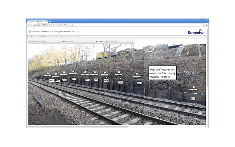
Site Monitor
The Site Monitor is customized with a graphic representing the site. This may be a map, technical drawing, or simply a photograph. Sensor icons are overlaid on this image and show the last reported value for that node along with its current Alarm status (e.g. clear/green/amber/red for multi-level alarm triggers). Clicking the sensor icon allows quick direct access to graphs for that sensor.
Data
The client has access to full reports and data sheets showing precise, uncompensated and stable data. The accuracy of Senceive data is corroborated by manual precise leveling. All of the cant data precisely sees movement making is effortlessly accurate.

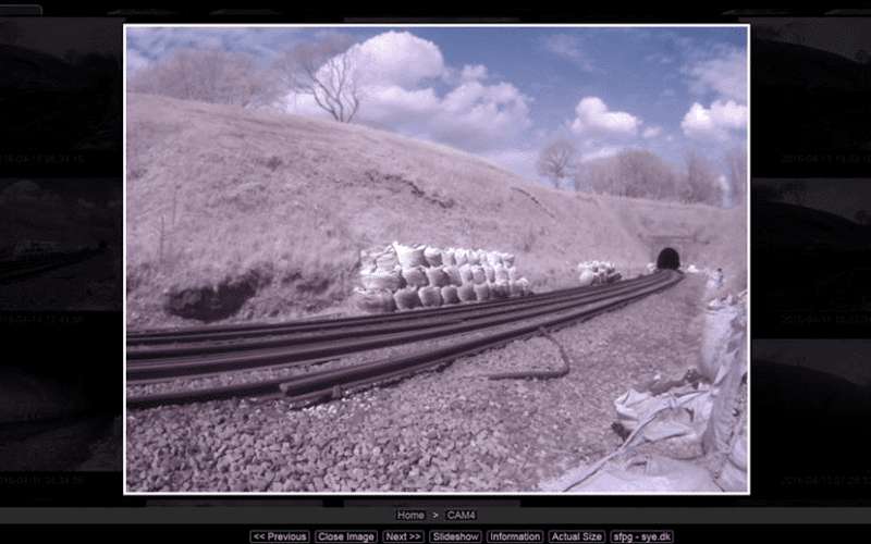
Camera Image Site Home Page
Any cameras on the site will also have their images shown on this page. Individual images can be selected and expanded if required.
Showing a captured image of the embankment site with a camera using a wide angle lens; in this case only one camera is deployed to cover a 100m section of embankment. The image can be downloaded and expanded/zoomed if required.
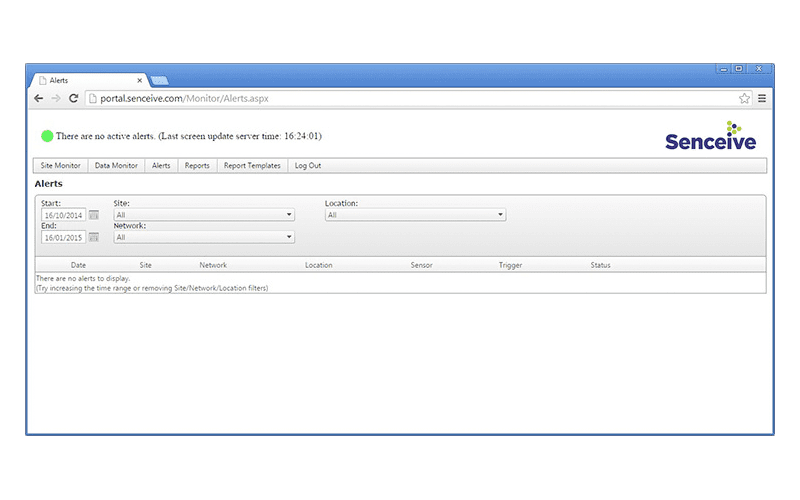
Alerts (Text and Email)
The client can have customized alert by individual node or group nodes which can be set up or reset at any time remotely. Text and email alerts are send to nominated individuals as agreed. Any data alerts, both active and historical, are shown as a summary list on the Alerts page.
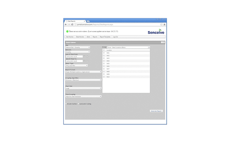
Reports
The Reports page allows the user to quickly generate graphs, tables and downloadable CSV files for one or more nodes.
Solutions
Frontier Precision provides world-class solutions for a wide variety of industries using leading products, training, technical services and more.
Products
Frontier Precision knows that every measurement its customers take is important. It’s why Frontier Precision not only offers the latest, cutting-edge measurement tools, but also understand the continuing need for service and support — because How You Measure Matters encompasses the total customer experience.
● Used & Clearance Equipment
● Rental Equipment
● Drones/UAS Aircraft
● Underwater ROV’s & Robots
● Survey
● Mapping & GIS
● Damage Prevention & Locating Devices
● Mosquito & Vector Control Software
● Invasive Plant Control Software
● Monitoring
● Scanning/Imaging
● Construction
● Augmented Reality
● Mixed Reality
● Forensics
● Water Resources
● Software
Technical Services
From Geospatial Services to GIS Professional Services to Water Resources Data Acquisition Services, Frontier Precision delivers leading-edge measurement technology. We’ve been there, every centimeter of the way, as geospatial technology has evolved. No matter what your need for accurate measurement, we have the experience and expertise to create a customized solution for you.
● Water Resources Data Acquisition Services
If you require customized technical services and training, please contact Frontier Precision at 800-359-3703 or reach out to a local Frontier Precision location.
Training and Events
From Geospatial Services to GIS Professional Services to Water Resources Data Acquisition Services, Frontier Precision delivers leading-edge measurement technology. We’ve been there, every centimeter of the way, as geospatial technology has evolved. No matter what your need for accurate measurement, we have the experience and expertise to create a customized solution for you.
- Technical Training & Events Calendar
- Technology Webinars
- Customized Training Request
- On-Demand Training
- Learning Lab
Frontier Precision offers affordable regularly scheduled certified training classes, online eLearning, webinars, as well as custom training options to meet your specific training needs.
Support
Frontier Precision provides world-class support from centers across a wide section of the western United States. Need support for any geospatial products, software or services?
Contact Frontier Precision at 800-359-3703.
About Frontier Precision
Frontier Precision’s measure of excellence can be traced back to 1988. Four years later, in 1991, Frontier Precision partnered with Trimble — a United States-based GPS equipment manufacturer at the time, and the rest is history. Since then, Frontier Precision has grown with Trimble to be one their largest and best geospatial distributors in the world.
We’ve been at the frontier of technology for three decades, continually offering customers new tools and solutions, all with our end goal in mind to help make our customers efficient, productive, and profitable with today’s and tomorrow’s technology. Frontier Precision is an employee-owned company — each of our team members is committed to your success.
Contact Frontier Precision
WHEREVER YOU ARE, WE ARE.
From our original office in Bismarck, North Dakota, we’ve grown our footprint thousands of miles in every direction.Today, you’ll also find us in South Dakota, Minnesota, Colorado, Alaska, Montana, Idaho, Hawaii, Wyoming, Oregon and Washington — delivering the Frontier Precision difference to more people each day.