Nearly every U.S. State has developed regulations for issuing NPDES (National Pollutant Discharge Elimination System) Permits under the Clean Water Act that allow regulated pesticides to be discharged to most waters of the United States. Before doing so, any entity or mosquito control organization seeking to obtain a permit from the state must first develop a Pesticide Discharge Management Plan and adhere strictly to federal and state regulations. Part of these regulations include creating and submitting various reports to oversight agencies that demonstrate the permit holder has not violated any pesticide discharge regulations.
Sentinel™ GIS Software for Mosquito Control was developed to help mosquito control agencies map all field activities related to mosquito control operations and to collect the necessary data to comply with state and federal pesticide discharge regulations. Since most states manage the NPDES Permits granted within the state, each state is responsible for defining what data must be collected during pesticide discharge operations and how that data must be reported to the oversight agency. This means that data collection and reporting requirements may vary state to state. For example, one state may require water quality analysis following a pesticide application while another state does not. Accounting for this variation in data collection requirements can prove troublesome in any standard software solution.
To compound this data collection issue, each agency operating under a state-issued NPDES Permit may have their own data collection needs or requirements that go beyond the state required data collection criteria. For example, a mosquito control agency may want to record data relating to the name of a Home Owner Association (HOA) where service is being provided. This information might be used by the mosquito control agency to generate invoices to be submitted to the HOA or may simply be used to report the number of inspections or treatments made in the HOA community. This data may prove very valuable to the mosquito control agency, but isn’t state required data.
Recent updates to the Sentinel™ GIS Adulticiding software application allow software users to define “Custom” data collection that can be configured to address unique data collection requirements. The software may be configured to add an additional five (5) user defined data collection fields to any ULV Adulticiding record.
This blog post describes the Sentinel™ GIS Adulticiding software tools used to create and configure user-defined “Custom” data collection forms. Sentinel™ GIS Adulticiding software already records date, time, and location of each ULV Fogging mission. The software also automatically records GPS position, pump status, pesticide flow rate, and other data associated with the ULV Fogging mission. For this exercise, let’s assume that a mosquito control agency wishes to collect additional “Custom” data during normal ULV Adulticiding operations. These data include MILES driven during a ULV Fogging mission, AREA where the ULV Fogging mission occurred, any SERVICE REQUESTS that were addressed by the ULV Fogging Mission, and the HOA where the ULV Fogging Session occurred.
The rest of this article will describe how to customize the Sentinel™ GIS Adulticiding software application to add the CUSTOM data collection tools to address this organization’s unique data collection needs.
To begin adding the CUSTOM data collection tools, select the MOBILE APPLICATION CONFIGURATION UTILITY from the Sentinel™ GIS Adulticiding menu. This tool allows software users to configure the mobile application software and to adjust default data collection settings. This is a very valuable software tool to modify and customize the field software that records ULV Fogging missions.
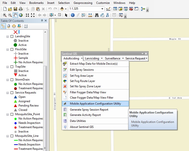
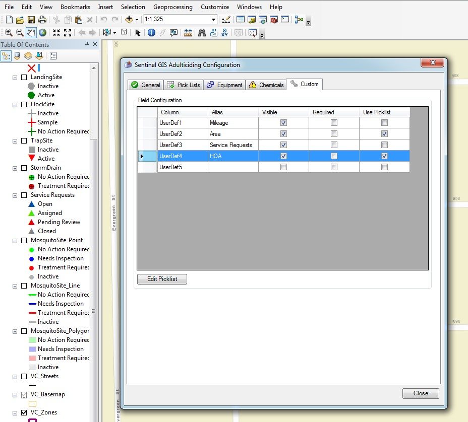
In the MOBILE APPLICATION CONFIGURATION UTILITY, select the CUSTOM tab as seen below. This tab is a new addition to the latest release of the Sentinel™ GIS Adulticiding software. Notice that users have the capability to configure and define five (5) custom data collection fields. In this example only four (4) of these custom fields will be defined.
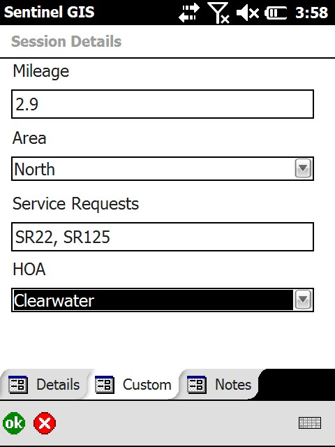
As mentioned, a mosquito control agency wishes to collect data regarding MILEAGE driven during a ULV Fogging session, the AREA within their operational boundary that the ULV Fogging session occurred, any public SERVICE REQUESTS that were addressed during the ULV Fogging Session, and the HOA where the work occurred.
Using the software tools, simply select the four (4) User Defined fields to be visible on the field PC.
Next, type in the Alias, or name, that you wish to be displayed on the Field PC during routine field data collection during ULV Fogging missions. In this instance, we have added “Mileage”, “Area”, “Service Requests”, and HOA to the four (4) visible User Defined fields.
Next, select the box for any of the User Defined fields that is required data to enter.
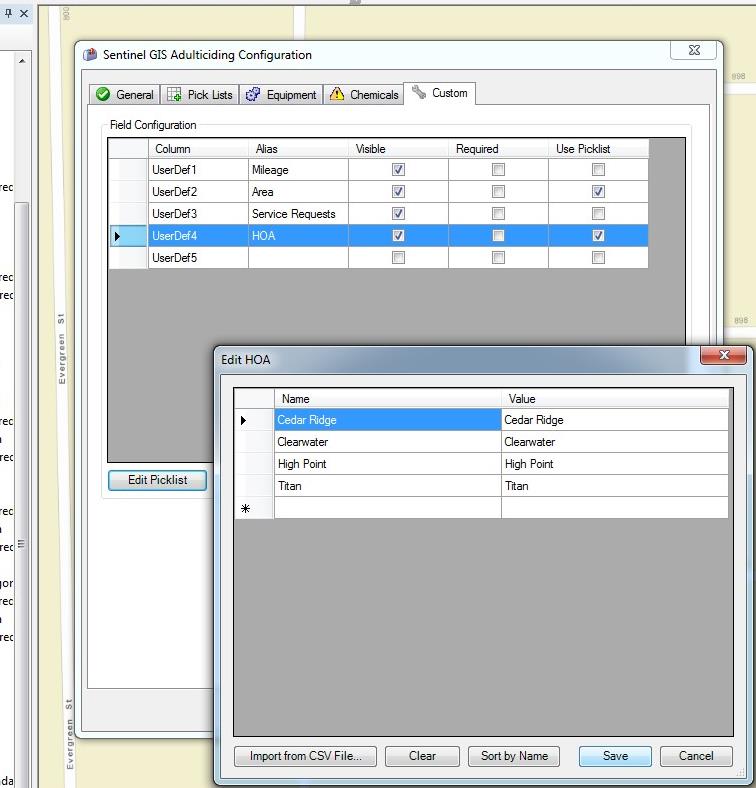
Lastly, select the “Use Picklist” box for each User Defined field where a pick list will be used. Then select “Edit Picklist” to start the dialog for picklist creation and editing.
In the example below, the Picklist Editor is used to create a list of Home Owner Association’s (HOA’s) within the service territory of a mosquito control operation. You may create and modify any picklist as needed. In this instance I have simply typed in the name of the HOA’s using a computer keyboard. However there is a very nice “Import From CSV FILE” software tool if you wish to quickly import a picklist quickly.
For the example below, I have created a pick list for the “AREA” and “HOA” user defined fields in Sentinel™ GIS Adulticiding.
Once you have finished defining the custom fields and created any picklists, press the “Save” button so that the modifications are preserved. Once this customization is saved, the changes and additions will be transferred automatically to the Field PC the next time the Field PC is connected to the computer. The customized data collection fields will be sent to the Field PC during the normal data synchronization process.
![]() To move the CUSTOM data collection fields to the Field PC, simply connect the Field PC to the computer and allow the normal Sentinel™ GIS software synchronization process to complete. This synchronization process is automated and will begin when the PC detects that a Field PC is connected. Once complete, the updated forms are ready for use during normal ULV Fogging sessions.
To move the CUSTOM data collection fields to the Field PC, simply connect the Field PC to the computer and allow the normal Sentinel™ GIS software synchronization process to complete. This synchronization process is automated and will begin when the PC detects that a Field PC is connected. Once complete, the updated forms are ready for use during normal ULV Fogging sessions.
The next step simply involves using the Field PC to collect data during a ULV Fogging session.
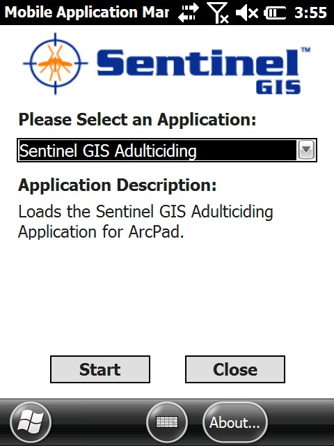
On the Field PC, tap the Sentinel™ GIS icon to launch the Application Manager. Select “Sentinel GIS Adulticiding” from the drop down list, as seen below, to being the Adulticiding software application.
Next, enter the session details information. Notice that a new Tab named “Custom” has been added to the Session Details dialog as seen below. Selecting this Tab will reveal the four (4) custom field that were defined in the desktop software. Select the “Custom” Tab.
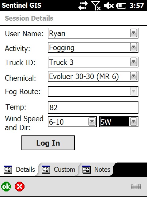
After selecting the “Custom” Tab in the Session Details dialog box, the four (4) customized data collection fields will be available for editing. These Custom fields may be edited prior to beginning a ULV Fogging Session and immediately following a ULV Fogging Session. They are not available for editing during a ULV Fogging session.
After entering the Custom data, either prior to the ULV Fogging Session or immediately following a ULV Fogging Session, the custom data will be transferred back to the PC and merged to the Sentinel™ GIS database with all other collected data using the automated data transfer and synchronization tools. Once synchronization between the field PC and the office PC is completed the CUSTOM data will be available on the desktop PC for review, and even available for editing if necessary.
After completing a ULV Fogging session and successfully synchronizing collected data from the Field PC to the Desktop PC, the CUSTOM data will be stored with all other data associated with the ULV Fogging session.
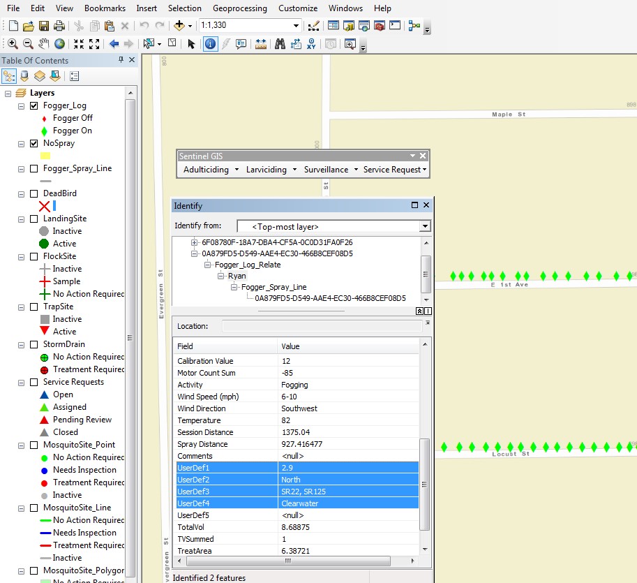
In the window below, I have used the standard ArcGIS Desktop “Identify” tool to select a point collected during the ULV fogging session that is displayed on the map. Doing this allows a user to see all data associated with the ULV Fogging session at that particular point and time. In the “Identify” dialog pop-up window, I have highlighted the data that I entered using the “Custom” tab when collecting this ULV Fogging session on the Field PC. This included the mileage driven during the ULV Fogging session, the Area where the ULV Fogging session occurred, the Service Requests addressed during this work, and the HOA that was served by this ULV Fogging session.
Please note that using the standard ArcGIS “Identify” tool is only one way to view the Custom data. These data are accessible to users during interaction with the database and available for report generation.
Using the standard Sentinel™ GIS Adulticiding software tools on the desktop PC, users can edit much of the data entered during any ULV Fogging mission. This includes the CUSTOM data entered into the four (4) user defined fields that were created during this exercise.
To do this, select the “Edit Spray Sessions” option under the Sentinel™ GIS Adulticiding menu option. Doing this will launch a Filter that will allow users to select a specific ULV Fogging session from many that may exist in the database. I encourage you to test this Filter tool to discover all of the capability available for use here.
Once you have successfully used the Filter tool to select the ULV Fogging session you were seeking, select the “Show Sessions” button found at the bottom of the dialog. In the next pop-up window, select the ULV Fogging session you wish to edit and press the “Edit” button found at the bottom of this dialog.
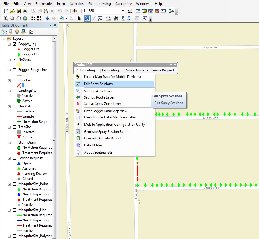
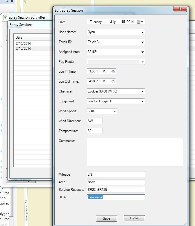
After successfully using the “Edit Spray Sessions” software tool you will see a pop-up window similar to the one below. Please notice that you may edit or change any of this data as needed so this is a software tool best suited for use by Supervisors or Adminstrators.
Found at the bottom of this pop-up dialog window is the CUSTOM data fields that were configured at the beginning of this exercise and collected during a typical ULV Fogging mission. This data may be edited if needed.
This recent addition to our Sentinel™ GIS Adulticiding software allows software users to quickly and easily define CUSTOM data collection fields that meet their unique needs. Whether collecting data required by State oversight agencies or collecting data required by the mosquito control agency, having the ability to create custom data collection tools should meet most unique data collection requirements.
View More Information about Sentinel GIS
Solutions
Frontier Precision provides world-class solutions for a wide variety of industries using leading products, training, technical services and more.


Products
Technical Services
If you require customized technical services and training, please contact Frontier Precision at 800-359-3703 or reach out to a local Frontier Precision location.
Training and Events
Frontier Precision offers affordable regularly scheduled certified training classes, online eLearning, webinars, as well as custom training options to meet your specific training needs.
About Frontier Precision
Contact Frontier Precision
