Comparing Techniques to Link or Attach Photos to GIS Field Data
How do I take photos in the field and link them to my GIS data in the office? There have been so many techniques and options over the years that it’s difficult to keep track of the solution that’s right for you. The technique you use will depend on the field software you are running.

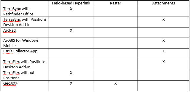
You might notice that not only does the field software matter, but now the software you use to process the data may also make a difference. Let’s look at each option a little more closely.
Field-based hyperlinks: The pathway or relative pathway to the photo is stored in a field in the feature class or shapefile. Using either the Identify tool or the Hyperlink tool, you are able to click the feature and view the linked document. The benefit is that you can manage a large amount of photos and store those photos where you have enough memory. The drawback is that if you want to link multiple photos to one feature, you need to have multiple fields to store the pathways or use Dynamic Hyperlinks that will not be supported in the field software. In addition, if you change the pathway or move the photos, you could potentially have a lot of work to re-link all the photos to their associated features.
No matter which software you have that uses hyperlinks, you will be required to create an attribute to store the hyperlink pathway. In TerraSync, you need to create a File Name attribute in your data dictionary. For ArcPad, you must have a Text attribute designated to store the information. In TerraFlex, just add an Image attribute. When data comes in, the software will do its best to make the workflow seamless, but you must remember that if you move the photos after the pathway has been entered into the attribute, you will break the link and need to re-link those photos. We also recommend using the tools available in TerraSync and ArcPad to name photos based on the date and time to ensure photos are not overwritten by new incoming data.
Attachments: When photos are stored as attachments, they are stored in a related table within the geodatabase. This technique will not work with shapefiles. Because relationship classes are used to maintain that link, you must have an ArcGIS Standard or higher license to create the table and relationship. The database size can grow rapidly when storing large numbers of photos. However, this technique does allow more than photo to be attached to one feature as well as allowing access to the photo in multiple ways: from the Identify window, the attributes window when editing, the attribute table window and through HTML pop-up windows. Most field software is moving toward using attachments to collect and store photos.
In every software listed above that uses attachments, setup is very simple. Just right-click on the feature class in ArcCatalog and go to Manage>Create Attachments. Now, when you check data out to the field or create TerraFlex Forms from Trimble Positions, the layer is already prepped to collect and store photos. Each software manages that a little differently between field and office, but the results are the same. The database can be moved or shared and the links will not be broken.
PLEASE NOTE! If you disable attachments on a layer that has photos attached, your photos will be lost. We highly recommend a regular backup of any database that is using attachments to store photos.
Raster as attribute: Though not used much by field software, storing a photo as a raster attribute is still a valid and useful technique. Storing a raster as an attribute requires a geodatabase and will not work with shapefiles. A feature class can have one attribute field that contains a raster dataset so that, similar to attachments, the photo is stored within the geodatabase. This time it is stored in the individual feature record rather than in a related table. And just like attachments, the geodatabase size can quickly explode if you are collecting thousands of photos.
The GeoJot software provides a few different options for geo-referencing photos, and once geo-referenced, it can output to many different formats. When outputting to a geodatabase, embedding the photo as a raster is one of the options. There is other software available on the market that offers this solution, but GeoJot is currently the only one supported by Frontier Precision.
Contact Frontier Precision for additional information on any of the software or workflows above. We’re here to help.


