#GISDay 2020 – What is your GIS story?
On the eve of #GISDay 2020, I want to ask the simple question, “What is your GIS Story?”
Now, I’m not asking you to boast and bluster us with years of accrued trivial knowledge of spatial awareness. I’m genuinely curious, do you remember the fork in the road that introduced you to GIS technology?
Your introduction may have been a part of a required educational curriculum to attain your degree or possibly you were thrown to the wolves at work one day when asked to “just figure it out.” Wherever you’re at today with utilization and dependency of spatial technology – you started somewhere!
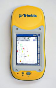
Similar to many of you, my introduction to GIS was a bit trivial, as maps were nothing new to me. I grew up watching the digital revolution mold and form before my eyes, into the instant access of information it has become today. However, I never put it all together in my head until someone handed me a Trimble 2003 Series GeoExplorer (roughly 15 years ago), and the light-bulb finally turned on that a person had to capture and create the data that was put on a map. Furthermore, someone had to plan the project, structure the information being gathered, analyze the findings, and communicate the information visually to make the map!

Like many of us, my GIS story started with the gathering and collection of data. Move ahead 15 years and working with spatial technology has since opened my eyes to see that almost all of the developed world relies on this technology, but so many are still in the dark and haven’t been formally introduced! They interact with it every day on both global and local levels. For example, scientists use it to help solve complex global problems, and organizations manage and streamline operational processes. We use it to forecast future events by analyzing insightful patterns and trends, and it even helps us find and navigate our way. GIS and spatial awareness have become so ingrained into everyday life that we oftentimes take for granted how we’ve gotten here.

More so than ever before, our GIS team at Frontier Precision has been helping organizations leverage the power of GIS. Whether it’s through helping customers implement new data collection workflows, breaking down departmental silos of data, aiding with system integrations, implementing asset and operations management solutions, or merging location and business intelligence – one common principle remains true, and it’s that after working with thousands of people over the past 15 years, everyone’s introduction to GIS was different and we all have a different story to tell.
“What is your GIS Story?”


