GPS Survey of Energia Costa Azul
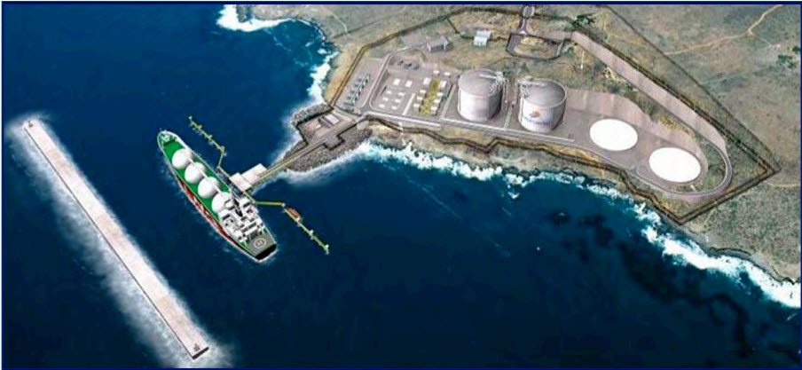
Earlier this month Jon Gipson of ASC Scientific and myself, Cliff Askew of Frontier Precision, embarked on a quick trip to Ensenada, Mexico to survey the breakwater at Energia Costa Azul. The goal is to verify that the breakwater is not being moved by the force of the ocean wave’s constant pounding. This Liquefied Natural Gas plant provides natural gas to a large area of Mexico.
Breaking waves:
Although the entire LNG terminal project was highly involved, a 2,150-foot (652 meter) long breakwater posed especially complex concrete placing and logistical challenges. Tackling the major task head on was a strategic combination of Putzmeister equipment, including separate placing booms and high pressure trailer-mounted concrete pumps. The high performance units placed concrete for 12 huge caissons. The caissons were of two sizes – each 82 feet (25 meters) tall, 125 feet (38 meters) wide and either 152 feet (46.25 meters) or 225 feet (68 meters) long.
The 12 gigantic caissons, each about the size of an eight-story office building, were towed out to sea and sunk to form a specially constructed breakwater. Since no natural harbor exists off the deep coastal waters of Costa Azul, this breakwater would protect LNG ships from being damaged by forceful ocean waves when unloading at a specially constructed 820-foot (250 meter) long berthing pier.
To design and construct the breakwater, the joint venture of China Harbour-Costain was awarded the $170 million contract. The breakwater construction tasks were divided within the joint venture, and the Costain Group PLC (Costain) of London was responsible for the specialized concrete work of the caissons. Costain, an international engineering and construction group founded on over 140 years of experience, refers to the challenging project in their company news magazine as “a world first, as no one has ever put such massive sized caissons in the Pacific Ocean.”
“It certainly took a great deal of ingenuity to develop the most efficient plan for concrete placement during caisson construction,” says Bob Liebermann, Special Products Sales Manager at Putzmeister America, Inc. “The strategic arrangement involved placing concrete for the caissons within a specially created casting basin, then floating them to a jetty to finish the concrete placing process, and finally towing them 14 miles (23 kilometers) out to sea for placement.” Read full article here.
We originally surveyed this enormous concrete structure back in 2012. Our first survey was indeed a challenge because it was incredibly difficult to locate the survey pins. The survey pins are very small and many are below the surface of the concrete. To add to the difficulty, the entire breakwater was covered by a thick accumulation of pelican droppings!
This year’s survey was DIFFERENT! We had realtime, centimeter differential correction! I was able to find the pins in seconds!!! Yes, I realize it may seem that I am way too excited about realtime differential correction. I guess you would have had to spend hours scraping and scraping to find the survey pins to really appreciate the HUGE benefit of realtime centimeter accuracy. We did not have access to any VRS, Cellular, or any other way of getting realtime on the site. We used a Trimble NetR9 outputting corrections over an Intuicomm RTK Bridge. Over on the rover side, we were using a Trimble Geo 7X with a Pacific Crest XDL radio to receive corrections from the NetR9 .
For more information about the set-up and use of the NetR9 , RTK Bridge, and XDL rover, checkout www.gpsprioritysupport.com.
I created a short video of our adventure:
https://youtu.be/C34RmIWUKT4


