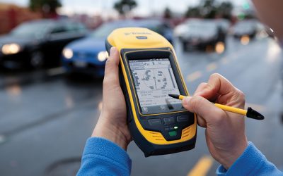
Frontier Precision and Industry News

Trimble Feedback: Connecting with Community

Trimble Feedback: Connecting with Community

If you are part of a utility organization (electric, water, or gas) or municipality, you may want to look into Trimble Feedback. Trimble Feedback is an easy-to-use Web-based system that provides a communication channel between a utility and its customers and interest...

read more

Six New Tech Talks Posted!

In the past week we have added six new tech talks, four of them added just today. The latest Tech Talks include: Tilt Sensor Calibration for the Trimble R10   Measuring a Compensated Point with the Trimble R10   Measuring in Tree Canopy with the Trimble R10...

read more
Trimble GNSS Planning Website

Trimble GNSS Planning Website

Did you know that Trimble has a free online tool to help you plan your GNSS data collection efforts? GNSS Planning Online will help you find the best period of time to hit the field. 1.) Indicate your location. Pick it from the map or type in its known coordinates....

read more
GPS Survey of Energia Costa Azul

GPS Survey of Energia Costa Azul

Earlier this month Jon Gipson of ASC Scientific and myself, Cliff Askew of Frontier Precision, embarked on a quick trip to Ensenada, Mexico to survey the breakwater at Energia Costa Azul. The goal is to verify that the breakwater is not being moved  by the force of...

read more

New Tech Talk- Trimble R10 Tilt Sensor Calibration

When working with the Trimble R10 GNSS receiver, it is very important that the internal tilt sensors get calibrated properly, and on a regular basis. We put together this Tech Talk to help you find your way through the settings, and to properly calibrate the tilt...

read more
Windows Mobile/WEHH Memory Usage Trick on ArcPad

Windows Mobile/WEHH Memory Usage Trick on ArcPad

Recently Juniper Systems posted this article on their blog, Get Rugged. We found this information to be very valuable and wanted to share. One thing you may have found while using Windows Mobile or Windows Embedded Handheld is that the operating system has a 32 MB...

read more
City of Bozeman takes Stormwater Mapping to the Streets

City of Bozeman takes Stormwater Mapping to the Streets

In early 2012, the City of Bozeman GIS Department was asked to create a comprehensive map of the City’s stormwater system, supporting both the Bozeman Stormwater Program and Montana Department of Environmental Quality (DEQ) permit for stormwater discharge. The...

read more
Flow Calculation App for iOS and Android

Flow Calculation App for iOS and Android

For people in the field who have to calculate flow for flumes/weirs, open-channels, and partially full pipes, Teledyne ISCO has created a very handy application for your iOS or Android smart-phone or tablet called ISCO FlowCalc. This app includes conversions for...

read more
Using ArcGIS Online for Mosquito Control Management

Using ArcGIS Online for Mosquito Control Management

Sharing data with decision makers and the public is an essential part of mosquito control management. ArcGIS Online provides an easy-to-use platform for creating web maps, and sharing these as web apps or via social media such as Facebook or Twitter. ArcGIS Online...

read more
When Deciding What Coordinate System to Use…

When Deciding What Coordinate System to Use…

When deciding what coordinate system to use (or export to) after collecting GNSS data in the field with a spatial reference of Latitude, Longitude, WGS-84, HAE in meters, there’s really no “correct” one.  The decision should be based on how you want to project your...

read more
Water Quality Enters the 21st Century

Water Quality Enters the 21st Century

One of the most frequently asked questions I get when I’m visiting customers is, “when am I going to be able to collect water quality data on my iPhone or iPad?”  It’s a fair question since almost everything we do in our daily lives is directly tied to our phones and...

read more
Customize ArcPad’s ‘Use-Once’ Map Navigator

Customize ArcPad’s ‘Use-Once’ Map Navigator

ArcPad’s Map Navigator is a convenient way to zoom in or out and pan around your map without having to change the toolbar you are currently using.  But have you ever been frustrated by its ‘use-once’ property?  When you tap the Zoom Out or Pan buttons, they are used...

read more