Mapping and GIS

Mosquito/Vector Control

Frontier Precision provides complete office and field solutions for mapping, collecting and reporting Integrated Mosquito Management Plan activities. FieldSeeker® GIS for Mosquito Control software is designed to be the hub for all important data so it may be shared, analyzed, or updated throughout an organization.


Field and Office Solutions for Mosquito/Vector Control

FieldSeeker Core

  • Larviciding with Storm Drain Treatments
  • Surveillance
  • Service Request
  • Import Aerial, Truck and Drone Data
  • Optional VectorSurv Gateway Integration

FieldSeeker Windows ULV Adulticiding Extension

Frontier Public Notification App
Why the Esri Platform? GIS Professional Services
Mobile Devices for Reliable Data Collection
NEW! FieldSeeker GIS for Invasive Plant Control Software

Drone (UAS)  Sales and Services


FieldSeeker Core

Field and office tools for workflows associated with Larviciding with storm drain treatments. Surveillance and Service Request

FieldSeeker Core is a cloud-based system leveraging the Esri® ArcGIS® Online or ArcGIS Enterprise platform to provide users with simple, intuitive tools for mapping, collecting and reporting data related to mosquito control activities. Field and office users benefit from seeing a common up-to-date picture of their operations. Data is centrally located so it may be shared, analyzed, or updated throughout an organization.

FieldSeeker Core, an all-in-one app, includes tools for Larviciding with storm drain treatments, Surveillance and Services Request workflows. The cross-platform mobile app is easily deployed through the Apple Store, Google Play Store, and Windows Store and supports real-time connectivity with off-line editing capabilities. The FieldSeeker Core office suite is a Web app based on the Esri JavaScript API. There is nothing to install, access using any web browser. Since FieldSeeker Core is based on the industry standard Esri platform, the organization maintains full control and ownership of maps and data.

FieldSeeker Core Mobile App Tools
  • Larviciding Field Inspections and Site Treatments with Treatment Calculator
  • On-Truck Chemical Inventory
  • Storm Drain Treatments
  • QA Activities and Field Scouting
  • Adult Mosquito Trap, Landing Count, and other Field Sample Data for Surveillance Reporting
  • Manage Service Requests from Public
FieldSeeker Core Office App Tools
  • Dashboard Landing Page with Full GIS Mapping Capabilities with User Roles
  • System and Picklists Configuration
  • Management of Incoming Larviciding Data, Restricted Areas, Proposed Treatment Areas and Barrier/ULV Treatments
  • Surveillance Lab Data Entry and Management
  • Aerial, Truck, Drone Data Import
  • Optional VectorSurv Gateway Integration
  • Reporting and Data Search/Filter/Query and Review Options

Optional VectorSurv Gateway Integration for FieldSeeker Core

What started as the CalSurv Gateway in California is now known as the Vectorborne Disease Surveillance System, or VectorSurv. The system now serves California, Utah, New Jersey, Arizona, Hawaii, North Carolina, Tennessee, and the U.S. Territory of Guam with other states looking to adopt the system. Participating agencies use the VectorSurv Gateway to track, analyze, and share disease surveillance data for adult mosquito trapping, pooling, and testing; blood, tissue, or specimen samples (such as sentinel chicken blood samples and dead birds); and control efforts such as application treatments on larval sources.

FieldSeeker Core also supports collection and entry of all the same surveillance data, which is used in conjunction with other operational data to facilitate decision making and effective mosquito control activities. Because the same data needs to exist in each system for different reasons, FieldSeeker Core and VectorSurv have been integrated so that data can be synced in both directions eliminating double entry of voluminous lab data required for surveillance.

FieldSeeker Windows ULV Adulticiding Extension

Field and Office Tools for Recording Adulticiding Activities

FieldSeeker Windows ULV Adulticiding Extension is an end-to-end system for managing and reporting adulticiding activities. It is a standalone system consisting of a Windows 10 desktop office application and Windows 10 field collection application.


FieldSeeker Windows ULV Adulticiding Extension is built on Open GIS technology. Esri licensing is not required for standard operation but can be leveraged for advanced functionality and syncing data with FieldSeeker Core software. Spray session data is recorded by the FieldSeeker Windows ULV mobile app and stored in the Windows 10 mobile device. Mobile data is synchronized with the office using online storage services such as Google Drive or Dropbox, to a shared folder through Wi-Fi, or using removable USB storage.

FieldSeeker Windows ULV Office App Tools
  • Configuration of System
  • View Data Operations by Date, Spray Session, and GPS Point
  • Management of Zones and Restricted Areas
  • Customize Restricted Area Warnings and Messages for Drivers
  • Create Line-based Spray Routes for Drivers
  • Service Request Integration with FieldSeeker Core
  • View Truck Spray Data in FieldSeeker Core
  • Print and Export Tabular Reports with or without Maps
FieldSeeker Windows ULV Mobile App Tools
  • Collect Spray Session Information from Compatible Sprayers with Data Output
  • Draw in Treatment Areas for other Sprayers with no Data Output
  • Driver Sees Themselves on Map which Rotates as Route is Driven
  • Driver Turns Sprayer on (Green Line) or Sprayer Off (Red Line)
  • Receive Restricted Area Warnings and other Instructional Messages
  • Easy to Read Status Bar for GPS, Sprayer On/Off Truck Speed, and Sprayer Flow Rate
  • Fleet Management capabilities by integrating with CompassTrac vehicle tracking system for real-time fleet awareness. Additional EsriArcGIS Online compatible CompassTrac software, hardware and recurring cell plan required.
  • Optional Truck-mounted Weather Sensor for Automatic Recording of WS/WD, Temp, RH, BP

Frontier Public Notification App

Public Outreach Tool

Frontier’s Public Notification app is a public outreach tool designed to facilitate communication between members of the public and mosquito and vector control and public health agencies. It consists of a mosquito and vector control agency branded mobile app for iOS and Android devices and a Web app for agency admins to manage information and notifications pushed to the public mobile app.

Public mobile users can download the free mobile app from the app stores and subscribe to receive notifications for selected areas of interest, to submit service requests, and to view activity status maps. The mobile app will receive push notifications based on the user’s subscription preferences.

Agency personnel use the Web app to manage news and updates, notification messages, notification “zones” or areas, and other system settings.

Public Notification Mobile App
  • Free Public Mobile App Available from Apple Store or Google Play Store
  • Public User Subscribes to Notifications for Selected Area of Interest
  • Public User Views Activity Status Map Information Provided by Agency
  • Public User Enters Service Requests
Public Notification Admin Web App
  • Agency Personnel Manages News and Notifications pushed to Public Mobile App and User Subscriber List
  • Agency Personnel Manages Status Maps and Area of Interests using Esri ArcGIS Online

Why the Esri Platform?

The Esri ArcGIS Online platform offers cost savings over legacy server systems and allows multiple users to use the system anywhere, anytime.

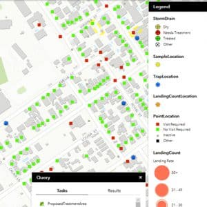
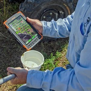
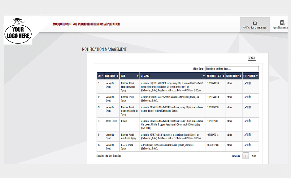
Esri keeps up with advances in the Geospatial Cloud technology while Frontier takes care of the development of the mosquito and vector control workflows. Together we deliver a powerful solution so organizations are free to focus on important control activities.


Value of the Esri platform includes:
  • ArcGIS is a scalable system to expand as needs grow and change.
  • ArcGIS Online continually earns security and privacy certifications.
  • ArcGIS lends configuration and data editing flexibility of the FieldSeeker Core apps.
  • ArcGIS Online provides additional data visualization and data sharing options with FieldSeeker Core data.
  • Customer maintains full ownership and control of maps and data.

Frontier GIS Professional Services

Frontier Precision’s GIS services group can offer innovative ideas extending other ArcGIS Online apps alongside the FieldSeeker GIS mosquito control workflows. We can help organizations achieve goals through focused consulting, configuration, implementation, training and technical support services.

Examples of extending the ArcGIS Online platform:


  • Integrating Service Request GeoForms or Survey123 Webforms with your external website, which allow the public to report on mosquito activity in their area.
  • Activity Status Web Maps can be utilized in a variety of applications to relay information to the public including: recent aerial or ground spraying activities, field inspections, open service requests, or the latest trap results or landing counts.

  • Email Notification and Service Request Routing system can be used to increase staff efficiency allowing more time spent on control measures while keeping residents more informed during the process.

Mobile Devices

For Reliable Data Collection

FieldSeeker Core is an all-in-one app including tools for Larviciding with storm drain treatments, Surveillance and Services Request workflows. It is a cross-platform mobile app deployed through the Apple Store, Google Play Store, and Windows Store.

The FieldSeeker Windows ULV Adulticiding mobile app is only compatible with Windows 10 tablets. Compatible sprayers output data using a 9-pin RS-232 serial connection which is only supported by Windows 10 tablets with serial connections built in.

In general, any professional, late model field device, phone, or tablet that has reliable GPS and meets minimum specifications can be used. Our approach is to list devices which have been tested and are known to support the FieldSeeker Core and ULV software. For a full list of devices, contact: Mosquito Support.

Juniper Systems Mesa 3 Rugged Windows 10 Tablet

Proven reliability — Over 800 units are currently used by mosquito control and public health agencies.

  • Field Rugged Windows 10 Tablet
  • Large 7 Inch, Sunlight-readable Display
  • All-day Battery Life
  • Wi-Fi for Wireless Data Synchronization
  • High Quality GNSS Receiver
  • Optional RS-232 9-pin Port Needed for Truck Sprayers with Data Output
  • Optional 4G LTE Multi-carrier Capable
  • 2-year Hardware Warranty with Optional Extended Customer Care Packages
  • Assembled and Repaired in Logan, Utah

Drone (UAS) Products and Services

For Mosquito and Vector Control Applications

Frontier Precision offers a variety of multirotor and fixed-wing drone solutions for mosquito and vector control applications. We can help determine the data deliverable product needed and recommend the best aircraft for specific applications. Whether you are interested in operating drones yourself or subcontracting a service provider to collect data for a project, Frontier can help you incorporate this exciting technology into your GIS workflows.

Mosquito Control Applications:


Drone Inspections
Locate Water or Vegetation to Identify Mosquito Breeding Sites

Applying Pesticides
Liquid or Granular Treatments

Mapping and LiDAR Applications
Map Large Areas Quicker

Benefits:

  • Promotes Safety having less People or Equipment in the Field
  • Lower Cost Alternative to other Ground-based Plane/Helicopter Applications
  • Micro-level Applications in Difficult Terrain or Hard-to-reach Locations
  • Rapid Deployment and Repeatable Approach to Traditional Methods


See our recently recorded webinar,
Using Drones (UAS) for Mosquito Control

Frontier has access to many models and accessories to configure a system for your unique needs. However, we have put together some packages to make it easy to get started.

Autel EVO II Pro 6K Rugged Bundle
  • High Quality Image and Video
  • Economically Priced
  • Complete Solution for Entry Level Users
  • Application Example—Mosquito Breeding Site Inspections

  • Fly in a Wide Range of Environments
  • Camera and Payload Options
  • Application Example—Measure Plant Health with NDVI as a way to Help Identify Breeding Area

          • Industry-leading Flight Time and Payload Capacity
          • U.S. Manufactured / Blue List
          • Application example – Granular Treatments

Mapping and LiDAR Options

  • A Larger Area can be Mapped in a Shorter Period of Time
  • Three-dimensional Information about the Surface of the Earth can be Recorded
  • Application Example—Up-to-date High Resolution Mapping of Potential Mosquito Breeding Areas after Construction and Development, Storm Events, or Seasonal Changes Before and After Mapping to Demonstrate Effectiveness of Abatement and Mitigation Efforts

Optional Training

Throughout the year, Frontier schedules Part 107 training classes or offers on-site Part 107 remote pilot certificate training sessions on how to best use new drone systems for mosquito control applications.


  • One Day—Part 107 Remote Pilot Certificate Training
  • Two Day—Part 107 Remote Pilot Certificate Training and Equipment in Mosquito Control Scenario Training
  • Three Day—Part 107 Remote Pilot Certificate Training and Equipment in Mosquito Control Scenario Training and Esri Site Scan for ArcGIS, Esri Drone2Map or Pix4D Training

Drone (UAS) Services Provided by Frontier

Not ready to own a drone system? Our UAS team can provide professional aerial drone services. Hire our certified, insured pilots to fly the job and provide high quality data deliverables. This is also a great way to get started with the latest technology under the guidance of our experienced pilots without the expense of owning the system until the time is right.

  • Multispectral Inspection Services
  • High Resolution Aerial Mapping
  • Image Classified and Feature Extraction
  • LiDAR and Photogrammetry Surveying

Legacy Products

Our Software Products Nearing Retirement or are Retired

The following is a list of our mosquito control software products that have been retired. Our current FieldSeeker Core (Larviciding with storm drain treatments, Surveillance and Service Request) and Windows ULV Adulticiding software are the migration path forward.

Please contact us to discuss your individual migration and data conversion plans.

Sentinel® GIS entered mature support in September 2018 and was retired December 31, 2020.

VCMS® and DataMaster® software are retired (formerly owned by Clarke and Electronic Data Solutions).

Solutions

Frontier Precision provides world-class solutions for a wide variety of industries using leading products, training, technical services and more.

Technical Services


If you require customized technical services and training, please contact Frontier Precision at 800-359-3703 or reach out to a local Frontier Precision location.

Training and Events


Frontier Precision offers affordable regularly scheduled certified training classes, online eLearning, webinars, as well as custom training options to meet your specific training needs.