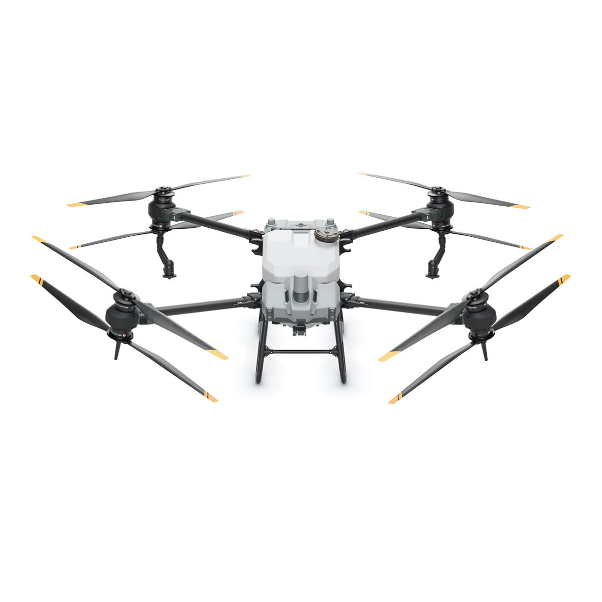


Description
Specifications
• 50kg spreading payload [1]
• 40kg spraying payload [1]
• Active Phased Array Radar + Binocular Vision
• Dual Atomized Spraying System
• Supports flight spraying / spreading and RC mapping
• Core Modules IPX6K [2]
• EFI Generator 15% fuel saving [3]
• Farmland: 21.3 hectare [4] per hour
• Orchards: 4 hectare [5] per hour
• Spreading: 1.5 tonnes of fertilizer [6] per hour
Massive Payload Increase Thanks to the Coaxial Twin Rotor
The AGRAS T40 features a coaxial twin rotor design that increases the payload capacity by 30% with a maximum payload of 50kg [1]. Its foldable design reduces the aircraft size by 70% for greater portability.
Spraying System | Dual Atomization for Even Spraying
• 12L/min
• Magnetic Drive Impeller Pump – the new magnetic transmission design completely isolates the pesticide from the motor, making the aircraft corrosion-proof and ultra-durable. Quick disassembly by hand for easy cleaning.
• Dual Atomized Centrifugal Sprinkler – the dual atomized spray disc ensures even droplets and more efficient pesticide usage. The proprietary centrifugal valve prevents leakage, avoids over-fertilization, and reduces pesticide use while protecting the environment.
T40 Spreading System (50kg payload [1]) | Enhanced Spreading Efficiency for Superior Performance
• Real-time Weighing – the aircraft is equipped with a weighing sensor that monitors the spread quantity and remaining payload
• Fast Disassembly and Cleaning – the spreading device can be dismantled in 3 minutes and washed with water
Active Phased Array Radar + Binocular Vision | Omnidirectional Obstacle Sensing
The Active Phased Array Radar is incorporated with a binocular vision sensor system to provide 360-degree horizontal omnidirectional obstacle sensing, offering optimal security. The detection distance of up to 50m [8] allows for intelligent terrain following, smooth scaling, and bypassing of multiple obstacles [9].
Mapping, Spraying, and Spreading, All in One
The AGRAS T40 combines mapping, spraying, and spreading functions, while its UHD camera and adjustable gimbal enable easy capture of your desired view. Farmland and orchard images can be captured in real time, and local maps can be generated using the remote controller with the D-RTK 2 Mobile Station. The system detects land boundaries and obstacles automatically, for quicker planning of flight routes over farmland and hilly orchards.
Fully Enhanced Remote Controller for Smoother, Faster Mapping
The 8-core processor makes mapping of 6.67 hectares possible in 10 minutes [10]. Minimizes wasted journeys with intelligent route planning, for greater efficiency. The large 7-inch high brightness screen offers broader view with refined detail. A wide range of custom physical buttons provides flexible control.
Autonomous Operation with Optimal Route Planning
The new intelligent route mode independently plans the best route for each operation. A gauge indicates the remaining liquid payload amount and estimated time until refill in real-time, letting operators strike the perfect balance between payload and battery life. The aircraft also supports automatic edge sweeping for extensive spray coverage and easier aerial operation.
Robustly Tested for Ultimate Reliability
The core components are designed to withstand complex and harsh farmland environments. They have passed a host of rigorous tests such as corrosion prevention, high and low temperature, and aging tests, to ensure peace of mind for the user.
Ultra-fast Charging
12000W Multifunctional Inverter Generator with new EFI technology and 15% fuel saving [3]. The charging station produces 1500W AC output, sufficient to power the remote controller, water pump, reloader, lights, and other components. The 30,000mAh Intelligent Flight Battery with its standard air-cooled heat sink can cool down rapidly.
- D12000iE Multifunctional Inverter Generator
- 30L tank charges 47 batteries [11]
- 1500W AC output
- 9-min ultra-fast charging [12]
- T40 Intelligent Flight Battery
- Capacity up to 30,000mAh
- 11.5C while discharging, 6C while charging
- Warranty coverage of 1500 charging cycles [13]
DJI AGRAS Intelligent Cloud
By pairing AGRAS T40 with the Phantom 4 Multispectral, the platform allows you to perform variable spraying / spreading operations with the precision based on the farmland’s prescription map. The feature is useful for the spraying of fertilizers on rice, fertilizers and defoliants on cotton crops, and nutrient solutions on soybeans and corn.
1 Data was measured at sea level. The payload weight is greatly affected by the ambient temperature and altitude. The payload weight needs to be reduced by 10kg for every 1,000m increase in altitude. The DJI AGRAS app will recommend the payload weight according to the current status and surroundings of the aircraft. When adding materials, the maximum weight should not exceed the recommended value, otherwise flight safety may be compromised.
2 The core modules include: the avionics module, radio frequency module, breakout board, power distribution board, Electronic Speed Controller, Magnetic Drive Impeller Pump, Dual Atomized Centrifugal Sprinkler, Active Phased Array Omnidirectional / Backward and Downward Radar, Binocular Vision System, UHD FPV camera, and LED supplement light. The IPX6K rating is not permanent and may reduce over time after long-term use due to aging and wear.
3 When charging at 9kW, an EFI generator consumes 15% less fuel compared to a carburetor generator.
4 Data was subject to the operating environment and parameters. T40 flight parameters: consumption rate 15L/ha, spray width 11m, flight speed 7m/s, flight altitude 3m
5 Data was subject to the operating environment and parameters. T40 flight parameters: consumption rate 75L/ha, spray width 4m, flight speed 3m/s, flight altitude 2m
6 Data was measured with urea and subject to the operating environment and parameters. Actual data may vary in operation. T40 flight parameters: consumption rate 149kg/ha, spread width 7m, flight speed 7m/s, flight altitude 3m, spreading disc rotation speed 1,000rpm. The area is free of obstructions and in a regular terrain shape. The fertilizers are prepared in advance and can be loaded quickly.
7 Urea, seeds, and feed have small bulk density. The volume of their particles weighing 50kg will exceed 50L.
8 The effective sensing range varies depending on the material, position, shape, and other properties of the obstacle. Pilots are responsible for flight safety at all times. The obstacle avoidance is only an assisting tool.
9 The Bypass function should preferably be used in environments with sufficient daylight, and incline of less than 20 degrees, small obstacles, and few electrical wires. The function is not recommended for use at night, on a rainy day, or around many electrical wires.
10 The remote controller’s mapping time, which can be affected by the firmware version, survey type, and other relevant factors.
11 Charging from 30% to 95%, with the number of batteries chargeable depending on the battery level, idle time, altitude, temperature, and other factors.
12 Charging from 30% to 95%. Factors impacting charging time: the altitude of the charging station and the battery cell’s temperature is in the range of 15° to 70°C.
13 Batteries are covered by warranty for up to 1,500 charging cycles or 12 months, whichever ends first.
Solutions
Frontier Precision provides world-class solutions for a wide variety of industries using leading products, training, technical services and more.
Products
Frontier Precision knows that every measurement its customers take is important. It’s why Frontier Precision not only offers the latest, cutting-edge measurement tools, but also understand the continuing need for service and support — because How You Measure Matters encompasses the total customer experience.
● Used & Clearance Equipment
● Rental Equipment
● Drones/UAS Aircraft
● Underwater ROV’s & Robots
● Survey
● Mapping & GIS
● Damage Prevention & Locating Devices
● Mosquito & Vector Control Software
● Invasive Plant Control Software
● Monitoring
● Scanning/Imaging
● Construction
● Augmented Reality
● Mixed Reality
● Forensics
● Water Resources
● Software
Technical Services
From Geospatial Services to GIS Professional Services to Water Resources Data Acquisition Services, Frontier Precision delivers leading-edge measurement technology. We’ve been there, every centimeter of the way, as geospatial technology has evolved. No matter what your need for accurate measurement, we have the experience and expertise to create a customized solution for you.
● Water Resources Data Acquisition Services
If you require customized technical services and training, please contact Frontier Precision at 800-359-3703 or reach out to a local Frontier Precision location.
Training and Events
From Geospatial Services to GIS Professional Services to Water Resources Data Acquisition Services, Frontier Precision delivers leading-edge measurement technology. We’ve been there, every centimeter of the way, as geospatial technology has evolved. No matter what your need for accurate measurement, we have the experience and expertise to create a customized solution for you.
- Technical Training & Events Calendar
- Technology Webinars
- Customized Training Request
- On-Demand Training
- Learning Lab
Frontier Precision offers affordable regularly scheduled certified training classes, online eLearning, webinars, as well as custom training options to meet your specific training needs.
Support
Frontier Precision provides world-class support from centers across a wide section of the western United States. Need support for any geospatial products, software or services?
Contact Frontier Precision at 800-359-3703.
About Frontier Precision
Frontier Precision’s measure of excellence can be traced back to 1988. Four years later, in 1991, Frontier Precision partnered with Trimble — a United States-based GPS equipment manufacturer at the time, and the rest is history. Since then, Frontier Precision has grown with Trimble to be one their largest and best geospatial distributors in the world.
We’ve been at the frontier of technology for three decades, continually offering customers new tools and solutions, all with our end goal in mind to help make our customers efficient, productive, and profitable with today’s and tomorrow’s technology. Frontier Precision is an employee-owned company — each of our team members is committed to your success.
Contact Frontier Precision
WHEREVER YOU ARE, WE ARE.
From our original office in Bismarck, North Dakota, we’ve grown our footprint thousands of miles in every direction.Today, you’ll also find us in South Dakota, Minnesota, Colorado, Alaska, Montana, Idaho, Hawaii, Wyoming, Oregon and Washington — delivering the Frontier Precision difference to more people each day.