FieldSeeker GIS for Mosquito Control Cross-Platform Mobile App March 2021 Release
Hundreds of users have been using FieldSeeker Core for the past 2 field seasons, collections thousands of inspections and treatments, treating tens of thousands of storm drains, and servicing thousands of service requests. We continue to get our best ideas for product enhancement from our customers. Our March 2021 release contains an impressive number of enhancements that have been in the works for a while.
FieldSeeker CPMA
FieldSeeker CPMA is available on the Microsoft Store, iOS App Store, and Google Play Store. This year we only put out a few public releases during the field season just to cut down on impacts to operations. Our December public release will be Build #46 or #47, but most of those have been internal. We’ve spent hundreds of hours on QA testing of all the workflows, so we’ve caught and fixed a lot of issues before you’d ever become aware of them. We’ve also done end-to-end testing on ArcGIS Enterprise so that the experience there is seamless just like ArcGIS Online.
Most of our users are using either the Juniper Mesa 3 Windows 10 tablet (or the previous model, the Mesa 2) because they also use it for truck spray tracking using our Windows ULV software, or they’re using an Apple device (iPhone or iPad). On the Android front, some customers are using highly rated consumer phones or tablets, and a few are using rugged Android devices such as the Cedar Tree CT8 tablet. We did drop the Cedar Tree CP3 and CT8 from our approved device list for new customers, primarily because the version of Android that is available on them is now quite old and cannot be updated. We’re evaluating whether to recommend the Trimble TDC600 handheld, or an updated version of the Cedar Tree CT8 hitting the streets soon.
Location Tracking
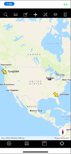
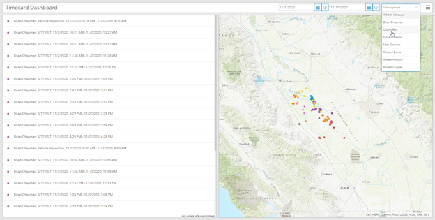
FieldSeeker now uses a LocationTracking layer to show the most recent location for field techs. Supervisors, managers, and crew members can see where field users were at most recently, which is convenient for logistics or work assignments. It can also help address safety concerns if there is an equipment breakdown, or a vehicle gets stuck, so that crew members know where to start looking.
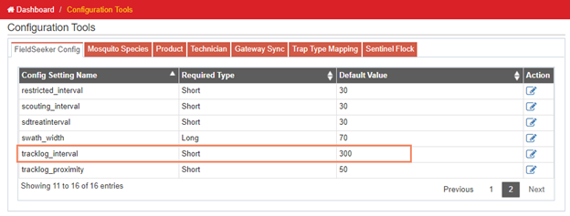
This layer is updated every 5 minutes (300 seconds) by default, but that can be adjusted in configuration settings on the office side by updating the tracklog_interval. We don’t recommend setting this lower than 60 or maybe 30 seconds at most. (Tracklog layer is no longer used – that functionality is replaced by this location tracking feature, and the Time Card feature discussed in more detail in the next section.)
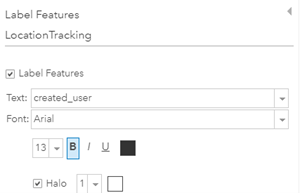
The LocationTracking layer may have to be added to the FieldSeeker Web map. You may also want to turn on the layer visibility to default to On/Visible. Set the layer symbology and labeling settings as desired so that they are easily visible on the map in the Office or on the mobile. In the example above, we’ve set the point symbol to be a large arrow, with labels for the user names.

You can also set the symbology to use a different symbol or color for each user if you want.

TimeCard Data and Review Today’s Work Report
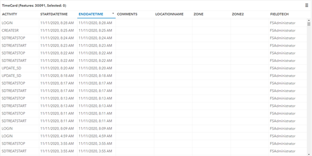
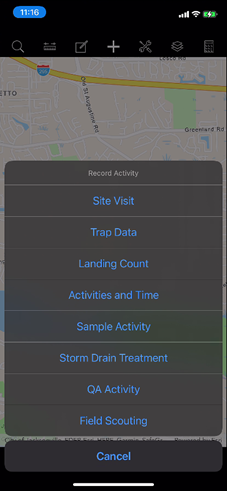
TimeCard has always been used for the miscellaneous Activities & Time entries, which can be recorded for map locations as related activity records, or as standalone features on the map.
![]()
But for a while now, the mobile app has been recording a Time Card entry any time the user takes any action in the mobile app – log in, create features, record activities, accept a service request, start storm drain treatment, etc. Anytime one of these action heartbeats is recorded, the date/time, technician, activity, and GPS location are recorded. That information is all visible in the TimeCard layer.
This data can be reviewed in the Office app in Data Review or on the map, or a simple Esri Dashboard can be set up to show this info with filters for date range and field tech name.
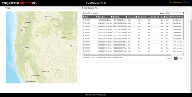
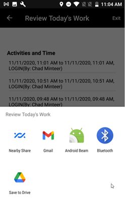
But we also added something new in the mobile application in Review Today’s Work. There’s now a Share Report button which will create a PDF showing a map and list of time card entries for the current logged in user. The report can be shared in any way that is supported by the device operating system.
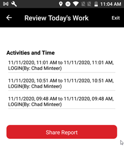
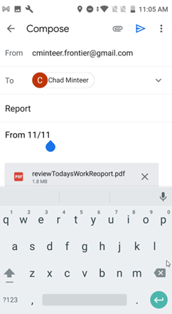
We think this will be a great workflow addition so that field techs can email their supervisor a time card report at the end of the day showing a basic list of everything they’ve done throughout the day and a basic map of where they’ve been.
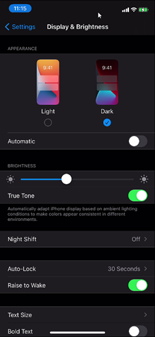
Dark Mode
Modern devices all have a “dark mode” which makes the device more readable in many lighting conditions and often tends to reduce battery usage. Android 10 and iOS 13 and later support dark mode. The CPMA app for Android and iOS is now responsive to this device setting. All FieldSeeker screens will now show light text on dark background when in dark mode. (Please note that before recent changes in the app to support dark mode, if you changed the device settings some FieldSeeker screens would appear not to show text values, because they would be black text on black background.)
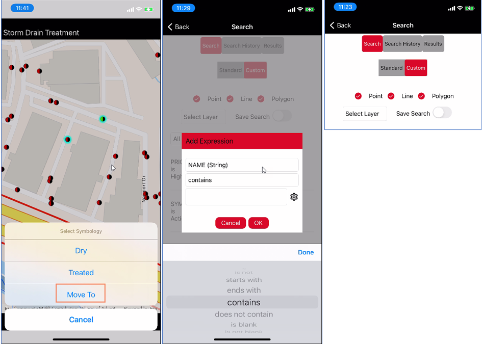
Custom Search
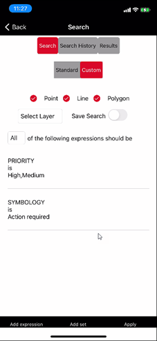
One of the biggest enhancements is the custom search tools. In Search, we now have the choice of Standard, which is the previously available search tools, and Custom. This is where we’ve added a bunch of new things.

For example, we can now support entering one search for Point, Line, and Polygon locations all together.
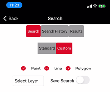
Or, you can select an individual layer, which includes any visible layer in the map, including additional non-FieldSeeker layers.

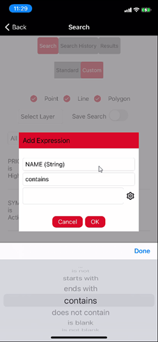
Down at the bottom of the screen, you will see buttons to Add expression and Add set.

Each expression supports any field and a wide variety of operators specific to the type of data. Data with picklists supports selecting multiple choices, and the list can be built from Value (current domain choices) or Unique (from the data).

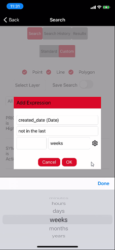
Operators for strings (text) include “is, is not, starts with, ends with, contains, does not contain, is blank, is not blank”. Numbers include “is, is not, is at least, is less than, is at most, is greater than, is between, is not between, is blank, is not blank.”

Dates include “is on, is not on, is in, is not in, is before, is after, is on or before, is on or after, in the last, not in the last, is between, is not between, is blank, is not blank” and “minutes, hours, days, weeks, years”.

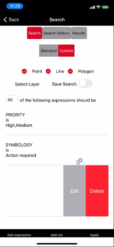
Expressions can be evaluated with for “All” (AND) or “Any” (OR). Expressions or expression sets can be edited or deleted (swipe left or tap-hold).
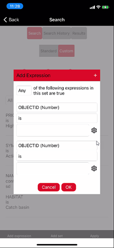
Add Set supports multiple expressions with Any or All, expressions can be added to the set.
Searches can be saved. Saved searches are displayed in Search History. Tap on the search to run it. Saved searches can be deleted.
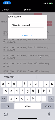

We think the enhanced search capabilities will make it that much easier to organize field work and create work lists.
Service Request Move
The mobile app now supports updating a service request location on the map or with GPS. This only works for Assigned requests. It’s available in the Service Request Manager > Assigned > details, and also on the map popup for SRs.


We added this capability so that service requests that weren’t located accurately due to geocoding errors or being placed on the map in the wrong place when they were created can be updated in the field by the field tech while they are on site, using GPS or by drawing on the map.
Storm Drain
Some of our users who treat storm drains treat tens of thousands of them multiple times per year, so we’ve been working closely with them to help smooth out the process anywhere we can.
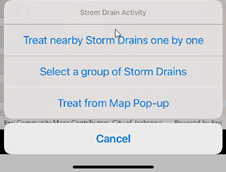
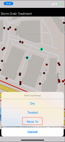
Storm drains can be treated in 4 different ways – the 3 mentioned when the user goes to Activity > Storm Drain Treatments, and also by7 editing a storm drain from the feature editing popup and changing the Symbology to Treated. This option now behaves consistently with other treatment workflows in terms of creating a treatment, adjusting inventory, and setting the storm drain symbology and attributes correctly.

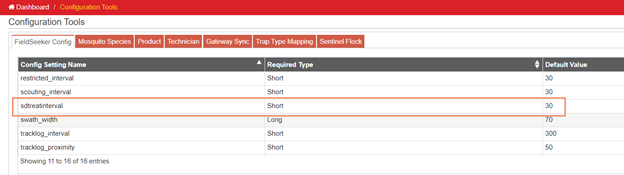
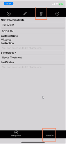
We now have a default storm drain treatment interval which is now applied in the case of a storm drain that is modified but not treated (such as marked as Dry). This setting defaults to 30 days, but it can be changed in the Office Configuration tools – look for the setting called sdtreatinterval.
Anything not “Treated” (for example, Dry) will have the Next Treatment Date set as Today + this interval.

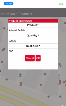
Products can now be configured with a default Storm Drain Dose and Storm Drain Treatment Area. This is also done in the Office Configuration tools > Product list.
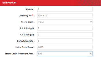
If these properties are set, then they will be loaded automatically when that product is selected for storm drain treatment in the mobile application.
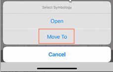
In addition, storm drains can now be moved or deleted, based on user permissions. These permissions are configured in the Office Configuration tools > Technician list. These options show up on the treat from map pop up list, or in the storm drain editing popup.
Wetlands Activities
Some of our coastal customers in the New England states have been looking for an easy way to save wetlands maintenance activity data along with FieldSeeker data. In the wintertime, waterway maintenance is commonly done. We now have a way to add additional feature and activity layers into FieldSeeker to be collected along with all the other data.
First, we run a utility program on our FieldSeeker server to create a wetlands service. This creates a WetlandsManagement feature service with a WetlandsLine layer and a related MaintenanceActivity point layer.
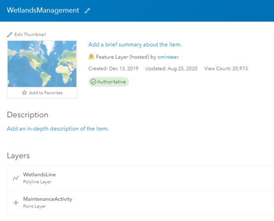
Next, we add these layers into the FieldSeeker web map and set up the symbology and popups.
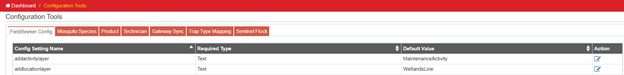
In FieldSeeker Office Configuration, we configure the addactivitylayer and addlocationlayer settings to make them aware of these new layers.
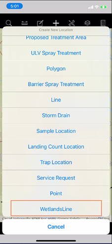
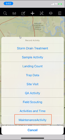
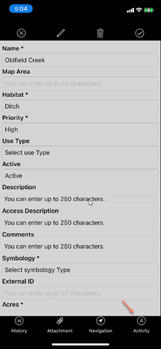
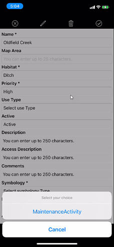
Now, the mobile app is aware of these new layers. The WetlandsLine layer will show up in the Create New Location list, and the MaintenanceActivity layer will show up in the Record Activity list.
So, users can record the WetlandsLine and MaintenanceActivity features, add attachments, view history, etc. on the mobile app.
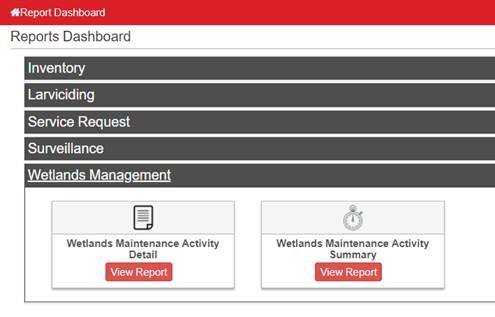
Then, on the Office side, there are some new Wetlands Management reports that show activity details and summary.
Getting the Update
The updated FieldSeeker Mosquito CPMA app can be downloaded by searching for app updates on the Store. This is usually automatic for iOS and Android, but that depends on your device settings. For Windows 10 tablets, you usually have to go to the Store and check for updates.
What’s New in FieldSeeker CPMA – March 2021 Video
See our Software Roadmap for more details.
If you have questions, please contact us.
Linda Glover, Sales Manager, (208) 324-8006
Chad Minteer, Product Manager, (208) 595-1435
Tyler McGarrity or Chris McCabe, Technical Support and Account Management, mosquitosupport@frontierprecision.com, (208) 324-8006
Solutions
Frontier Precision provides world-class solutions for a wide variety of industries using leading products, training, technical services and more.


Products
Technical Services
If you require customized technical services and training, please contact Frontier Precision at 800-359-3703 or reach out to a local Frontier Precision location.
Training and Events
Frontier Precision offers affordable regularly scheduled certified training classes, online eLearning, webinars, as well as custom training options to meet your specific training needs.
About Frontier Precision
Contact Frontier Precision
