FieldSeeker GIS for Mosquito Control Office Web App March 2021 Release
This is one of our most ambitious releases to date. We’ve added lots of great new features that will add flexibility, analytics, and data exploration.
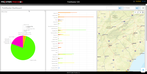
Embed Dashboard
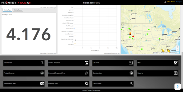
The FieldSeeker Office landing page has always had a few hardwired widgets displaying some key stats. But what if you want to display something completely different? What if you want to configure the widgets? Well now you can embed an Esri Dashboard, Insights Workbook, Story Map, or Web App Builder application. Below is an example of a simple Esri dashboard embedded in the landing page. This means you can build (or work with us so we can build) any dashboard showing any information you want and have that display on the main FieldSeeker landing page instead of the hardwired widgets.
We accomplish this by setting a few configuration settings in the FieldSeekerConfig table.

- dashboard_enabled = true
- dashboard_item_id = this can be found by browsing to the dashboard item in ArcGIS Online (make sure the item is shared with the group or in the same way that other FieldSeeker items are shared

- dashboard_portal_url = arcgis.com (or your Enterprise Portal URL)
To learn more about creating an Esri Dashboard, see our tutorial video, or contact us for services assistance.
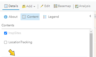
Location Tracking
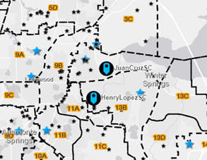
FieldSeeker now uses a LocationTracking layer to show the most recent location for field techs. Supervisors, managers, and crew members can see where field users were at most recently, which is convenient for logistics or work assignments. It can also help address safety concerns if there is an equipment breakdown, or a vehicle gets stuck, so that crew members know where to start looking.
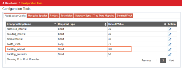
This layer is updated every 5 minutes (300 seconds) by default, but that can be adjusted in configuration settings on the office side by updating the tracklog_interval. We don’t recommend setting this lower than 60 or maybe 30 seconds at most. (Tracklog layer is no longer used – that functionality is replaced by this location tracking feature, and the Time Card feature discussed in more detail in the next section.)
The LocationTracking layer may have to be added to the FieldSeeker Web map. You may also want to turn on the layer visibility to default to On/Visible. Set the layer symbology and labeling settings as desired so that they are easily visible on the map in the Office or on the mobile. In the example above, we’ve set the point symbol to be a large arrow, with labels for the user names.
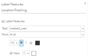
You can also set the symbology to use a different symbol or color for each user if you want.

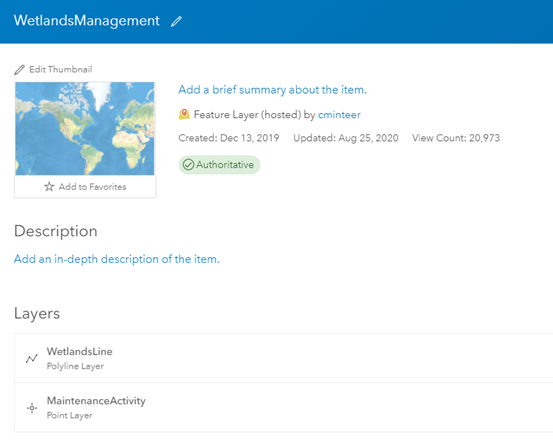
Wetlands Management Reports
Some of our coastal customers have been looking for an easy way to save wetlands maintenance activity data along with FieldSeeker data. In the wintertime, waterway maintenance is commonly done. We now have a way to add additional feature and activity layers into FieldSeeker to be collected along with all the other data.
First, we run a utility program on our FieldSeeker server to create a wetlands service. This creates a WetlandsManagement feature service with a WetlandsLine layer and a related MaintenanceActivity point layer. Both have feature attachments enabled so you can take pictures or attach other file types.
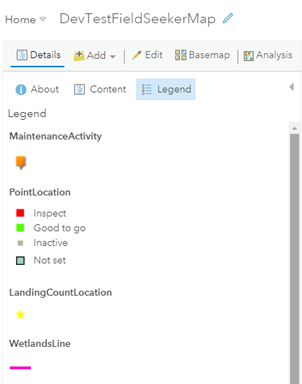
Next, we add these layers into the FieldSeeker web map and set up the symbology and popups.
In FieldSeeker Office Configuration, we configure the addactivitylayer and addlocationlayer settings to make FieldSeeker CPMA aware of these new layers.

Now, the mobile app is aware of these new layers. The WetlandsLine layer will show up in the Create New Location list, and the MaintenanceActivity layer will show up in the Record Activity list.
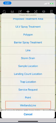
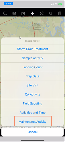
Users can now record WetlandsLine and MaintenanceActivity features, add attachments, and view history on the mobile app.


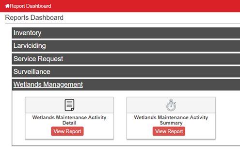
On the Office side there are some new Wetlands Management reports that show activity details and summary.
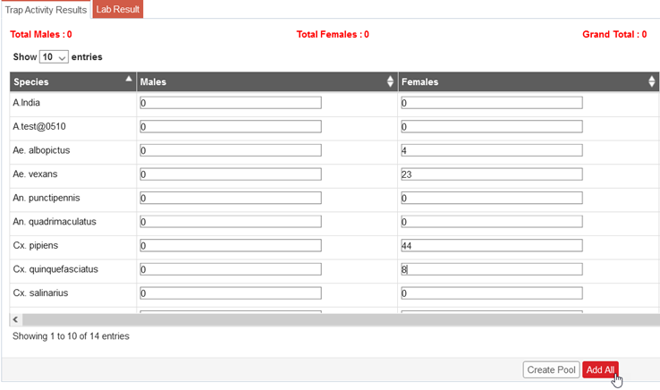
Trap Results
We now have a simple way to visualize Trap Results based on the Lab Tools data entry.
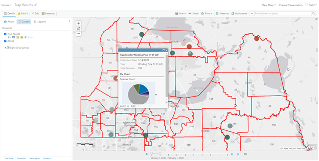
First, we run a utility program on our FieldSeeker server to create a FieldSeekerSurveillance service. This service has a TrapResults layer in it, which contains a single record for each trap day’s species counts (well, one for female, one for male, if males are being counted), which makes it easier to use for symbology, charts, and labels). This layer can then be used in any FieldSeeker map, and these settings will come through into the FieldSeeker Office program, and the popups will show charts and everything.

FieldSeeker CPMA is not smart enough yet to display the charts, but the map layer can be displayed including symbology and labels.
New Map Widgets
We’ve added several new widgets into the map that we think will help support visualization and data exploration.
Bookmark
The bookmark widget supports user-defined map extents with names called bookmarks. Simply zoom to the extent you want, click Add, and give it a name. You can edit or delete existing bookmarks. Bookmarks are user-specific.

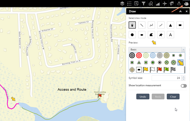
Draw
The draw widget allows you to add graphics and text to the map. Then you can use the Print widget to save the results as a PDF file. The graphics clear when you reload the map.
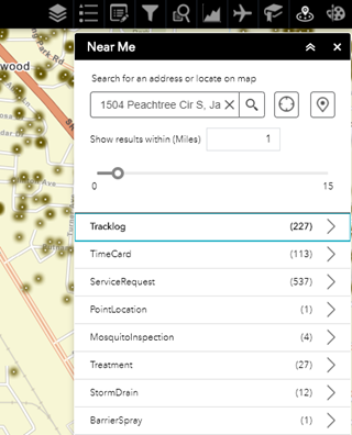
Near Me
The Near Me widget allows you to search for an address, use GPS, or click on the map, then show all the results within a configured number of miles. The results will show the count of features, then allow you to drill down into the details. It’s similar to the Info Summary but based on the proximity to some feature or address, which can be useful.
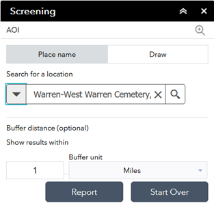
Screening
The screening widget is similar to the Near Me widget but it allows you to print a report from the results. You can choose which fields to include on the report, and you can also download the data as CSV, shapefile or file geodatabase.


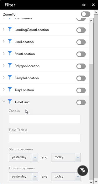
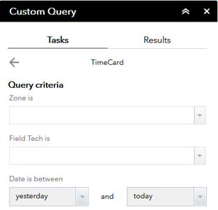
TimeCard Added to Query, Filter, Info Summary
In the interest of easier review for technician time card records, we’ve added TimeCard to the query, filter, and info summary widgets. This will facilitate supervisor review of employee activities for example.
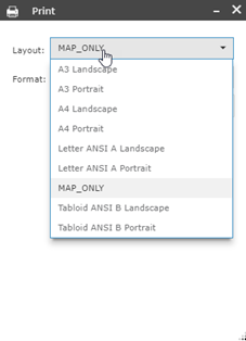
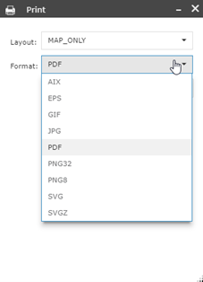
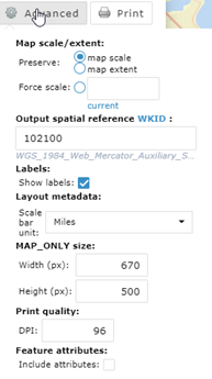
Enhanced Print
The print widget now includes all the advanced options. Multiple layout and format options are available. One cool example is that when you print a PDF map, you can include the attributes, and then people can interact with the map features and feature attributes using Acrobat Reader or other PDF viewers that can handle them.
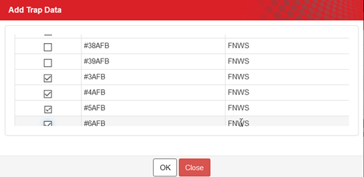
Adult Trapping Improvements
It is now possible to enter TrapData records for multiple trap locations at once.
Species Abundance records can now be added in bulk.
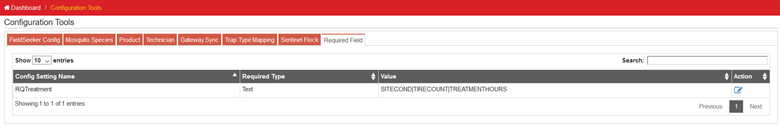
Required Entry for Weather
We now support setting required entry for Treatment fields that are not already required, as a way to facilitate requiring weather data entry.

Proposed Treatment Area Workflows
We’ve enhanced proposed treatment areas based on customer feedback.
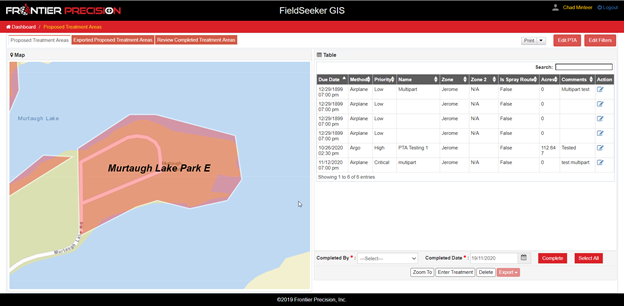
- You can now Print the map from here instead of going back to the main Map and having to print from there
- You can filter the list based on Priority, Method, Zone, and Due Date

- You can select one or more PTAs then use Edit PTAs to set a target product and app rate, which will be included in the exported shapefile, KML, or AgNav .no1 file

- If PTAs are intersected by Restricted Area polygons, the exported KML file will be created in a format that AgNav will import with exclusions
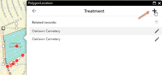
- When a Treatment is entered for a PTA, if the PTA intersects any PolygonLocation features, you can choose which feature to have the treatment attached to
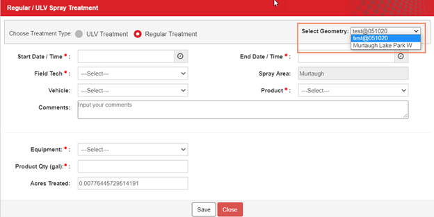
Create Related Activity from Map
Some customers want to be able to enter Landing Count records on the desktop, or treatments. You can now do this from the editing popup in the map.
First, you just have to make sure the related activity layers are turned on in the map.

Then, click the Edit widget.
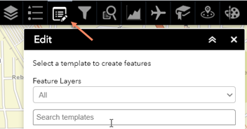
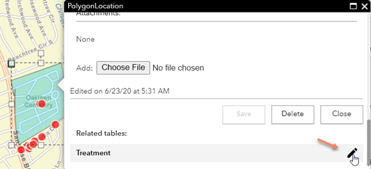
Click a feature, then scroll down on the popup. Click Edit on the related record, then click Add to create a new one.
Treatments will validate area vs. quantity, and if a Truck is specified, inventory will be adjusted.
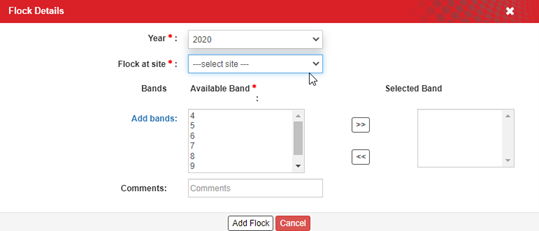
Sentinel Chicken Management
Some operations use Sentinel Chicken flocks as part of surveillance. FieldSeeker now supports creating a flock with chickens and attaching it to a SampleLocation. Configuration tools now has a Sentinel Flock tab.

When a flock is added, you select which bands (chickens) to add, and which site to attach it to.
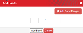
Add bands allows you to create additional ranges for chicken bands.
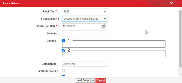
After this is all set up, in the Lab Tools > Sample Collections, when you sample a flock site, you choose which bands (chickens) to sample, and for each of them, a sample is created. That’s a lot faster than creating a new record for each and every chicken blood sample.
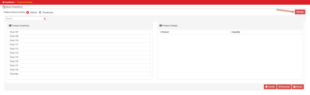
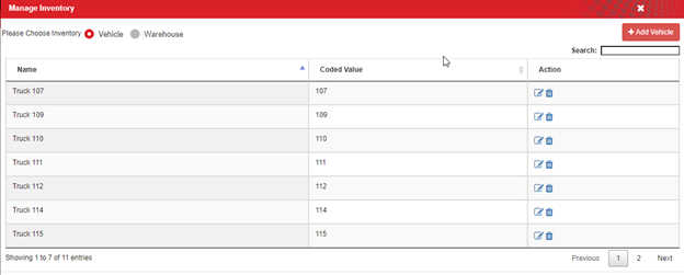
Inventory Location Management
If you’re signed in as the item owner for the FieldSeeker feature service, you can now manage inventory locations in the Product Inventory workflow. You’ll see a Manage button, and then you can add or remove warehouse and truck locations. This saves the trouble of having to log into ArcGIS Online, find the feature service, go to the data tab, look at fields, find the ProductInventory table, and adjust the domain list there.
ArcGIS Enterprise Data Store
For customers that use ArcGIS Enterprise, we now support the back-end ArcGIS Data Store. Most Enterprise customers (so far) use SQL Server as the back-end data store. ArcGIS Data Store creates feature classes and tables that are all in lower case, vs. SQL Server and ArcGIS Online which are all in UPPER CASE. So, we had to do a bunch of work so that queries, filters, configurations, and everything else take this into account. Anyway, what that means for you is that we can support any database back end that ArcGIS Enterprise supports, no matter the case. Good times.
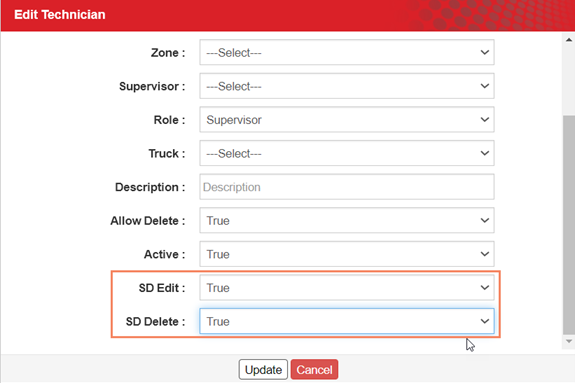
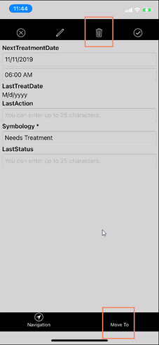
Storm Drain Configuration (Move, Delete, Default Dose and Area)
The mobile app now supports being able to move or delete storm drains and setting a default dose and area for storm drain treatment. These things are configured in the Technician list (for permissions to move or delete) and in the Products list (to set a default storm drain dose and treatment area).


Keep in Touch
Please stay in touch with us on our Community pages at https://support.frontierprecision.com. You can also contact us through Support if you have feedback and ideas for product enhancements.
Getting the Update
The updated FieldSeeker Office app will be automatically updated.
What’s New in FieldSeeker Office – March 2021 Video
See our Software Roadmap for more details.
If you have questions, please contact us.
Linda Glover, Sales Manager, (208) 324-8006
Chad Minteer, Product Manager, (208) 595-1435
Tyler McGarrity or Chris McCabe, Technical Support and Account Management, mosquitosupport@frontierprecision.com, (208) 324-8006
Solutions
Frontier Precision provides world-class solutions for a wide variety of industries using leading products, training, technical services and more.


Products
Technical Services
If you require customized technical services and training, please contact Frontier Precision at 800-359-3703 or reach out to a local Frontier Precision location.
Training and Events
Frontier Precision offers affordable regularly scheduled certified training classes, online eLearning, webinars, as well as custom training options to meet your specific training needs.
About Frontier Precision
Contact Frontier Precision
