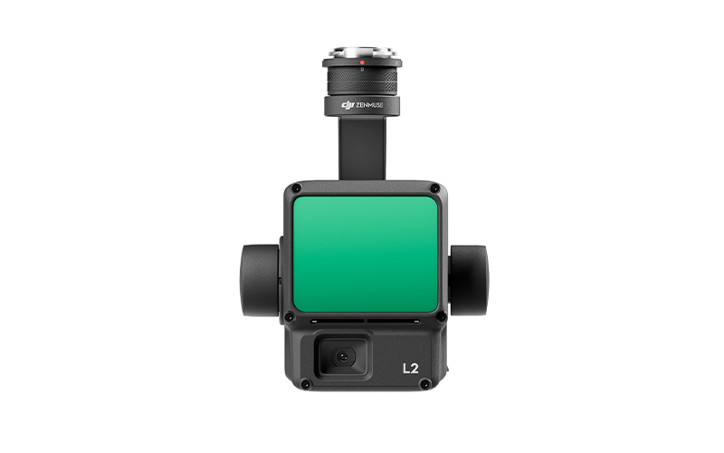
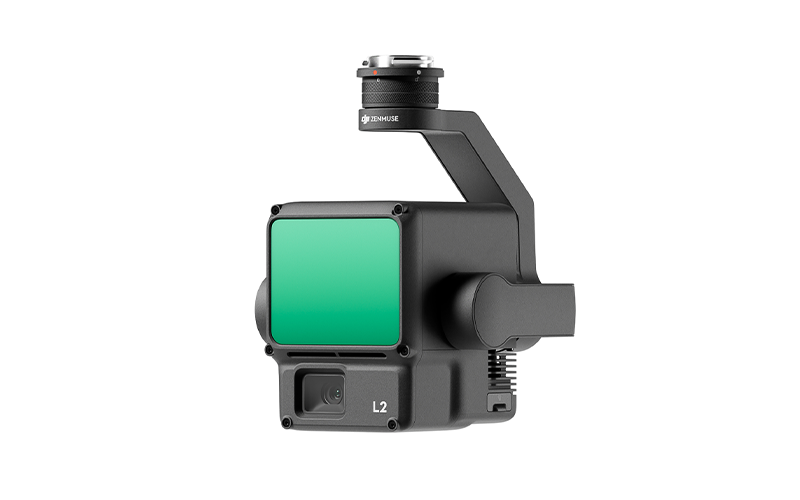
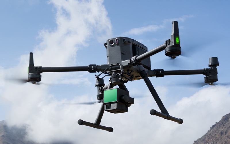
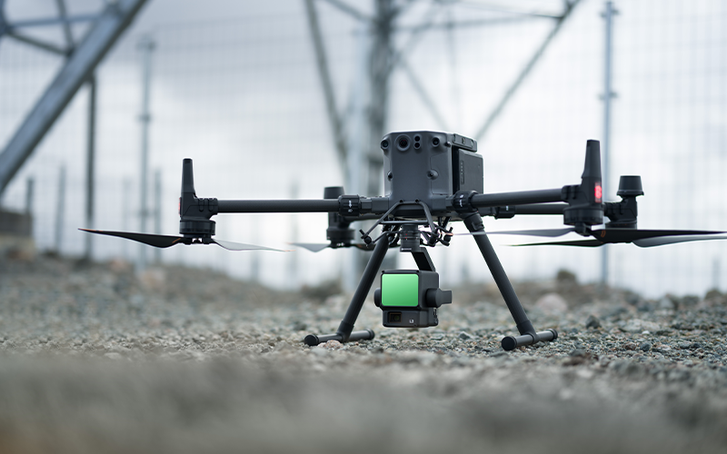
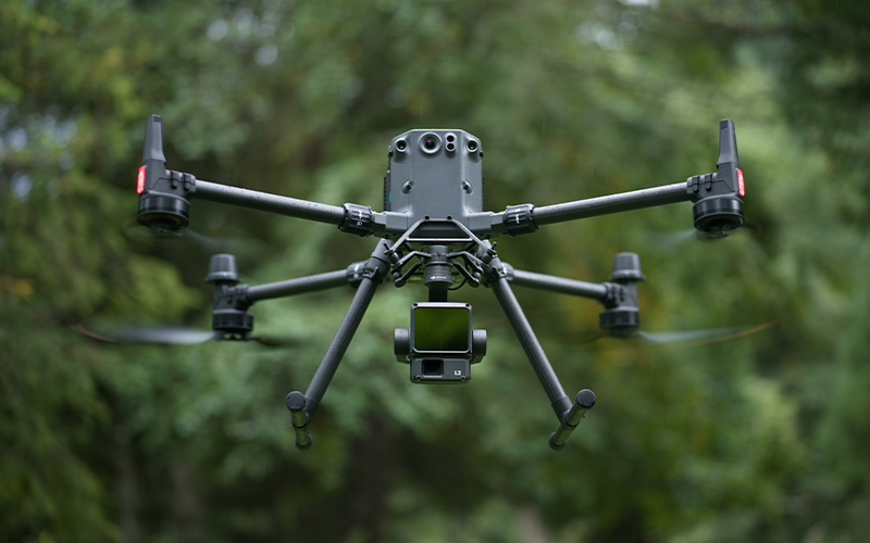
Zenmuse L2 integrates frame LiDAR, a self-developed high-accuracy IMU system, and a 4/3 CMOS RGB mapping camera, providing DJI flight platforms with more precise, efficient, and reliable geospatial data acquisition. When used with DJI Terra, it delivers a turnkey solution for 3D data collection and high-accuracy post-processing.

Description
Powerful Range, Elevated Precision | Integrated LiDAR Solution
Supported by its powerful hardware, L2 can allow for a precise scan of complex subjects within an extended range and faster point cloud acquisition. During operations, users can preview, playback, and process point cloud models on-site, with Task Quality Reports generated by DJI Terra, offering a simple, one-stop solution to improve overall efficiency. This enables users to achieve high-precision point cloud results with one-stop post-processing.
High-Level Precision
By combining GNSS and a high-accuracy self-developed IMU, this solution achieves 4cm vertical accuracy and 5cm horizontal accuracy. [1]
Exceptional Efficiency
It’s ready for work as soon as it’s powered on and can collect both geospatial and RGB data from a 2.5 km2 area in a single flight. [2]
Intuitive Operation
In conjunction with Matrice 350 RTK and DJI Terra, L2 offers a turnkey solution that is simple to use, lowering the operational threshold.
KEY FEATURES:
- High Precision – Vertical Accuracy: 4 cm; Horizontal Accuracy: 5 cm [1]
- Exceptional Efficiency – 2.5 km2 covered in a single flight [2]
- Superior Penetration – Smaller laser spots, denser point clouds
- Detection Range [3] – 250m @10% reflectivity, 100klx / 450m @50% reflectivity, 0klx
- 5 Returns
- Turnkey Solution [4]
- Point Cloud LiveView
- One-Click Processing on DJI Terra
1. Measured under the following conditions in a DJI laboratory environment: Zenmuse L2 mounted on a Matrice 350 RTK and powered on. Using DJI Pilot 2’s Area Route to plan the flight route (with Calibrate IMU enabled). Using repetitive scanning with the RTK in FIX status. The relative altitude was set to 150 m, flight speed to 15 m/s, gimbal pitch to -90°, and each straight segment of the flight route was less than 1500 m. The field contained objects with obvious angular features, and used exposed hard ground checkpoints that conformed to the diffuse reflection model. DJI Terra was used for post-processing with Optimize Point Cloud Accuracy enabled. Under the same conditions with Optimize Point Cloud Accuracy not enabled, the vertical accuracy is 4 cm and the horizontal accuracy is 8 cm.
2. Measured with Zenmuse L2 mounted on Matrice 350 RTK with a flight speed of 15 m/s, flight altitude of 150 m, side overlap rate of 20%, Calibrate IMU enabled, Elevation Optimization turned off, and terrain follow turned off.
3. The data presented are typical values. Measured using a flat subject with a size larger than the laser beam diameter, a perpendicular angle of incidence, and an atmospheric visibility of 23 km. In low-light environments, the laser beams can achieve the optimal detection range. If a laser beam hits more than one subject, the total laser transmitter power is split and the achievable range is reduced. The maximum detection range is 500 m.
4. After power is turned on, the IMU doesn’t require warm-up; however, users must wait for the drone RTK to be in the FIX status before it can fly and work.
Solutions
Frontier Precision provides world-class solutions for a wide variety of industries using leading products, training, technical services and more.
Products
Frontier Precision knows that every measurement its customers take is important. It’s why Frontier Precision not only offers the latest, cutting-edge measurement tools, but also understand the continuing need for service and support — because How You Measure Matters encompasses the total customer experience.
● Used & Clearance Equipment
● Rental Equipment
● Drones/UAS Aircraft
● Underwater ROV’s & Robots
● Survey
● Mapping & GIS
● Damage Prevention & Locating Devices
● Mosquito & Vector Control Software
● Invasive Plant Control Software
● Monitoring
● Scanning/Imaging
● Construction
● Augmented Reality
● Mixed Reality
● Forensics
● Water Resources
● Software
Technical Services
From Geospatial Services to GIS Professional Services to Water Resources Data Acquisition Services, Frontier Precision delivers leading-edge measurement technology. We’ve been there, every centimeter of the way, as geospatial technology has evolved. No matter what your need for accurate measurement, we have the experience and expertise to create a customized solution for you.
● Water Resources Data Acquisition Services
If you require customized technical services and training, please contact Frontier Precision at 800-359-3703 or reach out to a local Frontier Precision location.
Training and Events
From Geospatial Services to GIS Professional Services to Water Resources Data Acquisition Services, Frontier Precision delivers leading-edge measurement technology. We’ve been there, every centimeter of the way, as geospatial technology has evolved. No matter what your need for accurate measurement, we have the experience and expertise to create a customized solution for you.
- Technical Training & Events Calendar
- Technology Webinars
- Customized Training Request
- On-Demand Training
- Learning Lab
Frontier Precision offers affordable regularly scheduled certified training classes, online eLearning, webinars, as well as custom training options to meet your specific training needs.
Support
Frontier Precision provides world-class support from centers across a wide section of the western United States. Need support for any geospatial products, software or services?
Contact Frontier Precision at 800-359-3703.
About Frontier Precision
Frontier Precision’s measure of excellence can be traced back to 1988. Four years later, in 1991, Frontier Precision partnered with Trimble — a United States-based GPS equipment manufacturer at the time, and the rest is history. Since then, Frontier Precision has grown with Trimble to be one their largest and best geospatial distributors in the world.
We’ve been at the frontier of technology for three decades, continually offering customers new tools and solutions, all with our end goal in mind to help make our customers efficient, productive, and profitable with today’s and tomorrow’s technology. Frontier Precision is an employee-owned company — each of our team members is committed to your success.
Contact Frontier Precision
WHEREVER YOU ARE, WE ARE.
From our original office in Bismarck, North Dakota, we’ve grown our footprint thousands of miles in every direction.Today, you’ll also find us in South Dakota, Minnesota, Colorado, Alaska, Montana, Idaho, Hawaii, Wyoming, Oregon and Washington — delivering the Frontier Precision difference to more people each day.