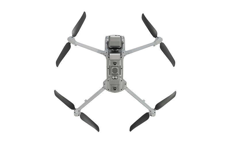
Description
• No Blind Spots
• Anti-jam, Anti-interference
• 15s Take off
• 8K 10x Optical Zoom
• IP43 Weather Rating
• Hot-swappable Batteries
• Navigation in GPS-denied Environments
• 12.4 Miles Transmission Range
• 42 Minutes Maximum Flight Time
• 720° Obstacle Avoidance
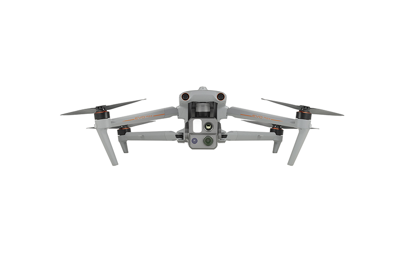
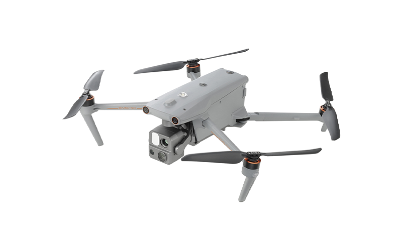
A Leader of Drone Intelligence
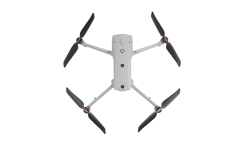
The EVO Max 4T brings powerful technologies and advanced autonomy to users. EVO Max 4T assesses complex environments to create real-time 3D flight paths for unparalleled obstacle avoidance. Advanced sensors make flight in GPS unavailable areas possible and the incredible new thermal payload unlocks new object identification and tracking scenarios. With a foldable, weather-resistant design, the EVO Max 4T is as portable as it is capable.
• Autonomous Path Finding: Autel’s Autonomy Engine collects surrounding environmental data and plans 3D flight paths through complex environments such as mountains, forests, and buildings. Use cases include rapid 3D scene reconstruction, public safety overwatch, industrial inspection, and land surveying.
• Navigation in GPS-denied Environment: Advanced sensors allow the EVO Max 4T to navigate within hardened structures, underground, or in environments without GPS.
• Accurate Object Identification and Tracking: Based on Autel’s AI recognition technology, the EVO Max 4T can automatically identify and lock onto different types of targets such as heat sources, moving people, or vehicles and achieve high-altitude tracking and data collection for law enforcement.
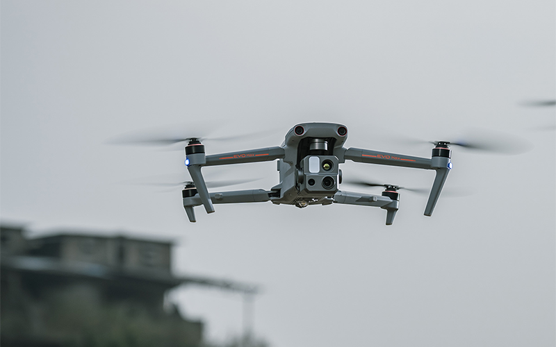
No Blind Spots | Ultimate Obstacle Avoidance
EVO Max 4T is the only commercial drone that combines traditional binocular vision systems with millimeter wave radar technology. This allows the EVO Max 4T’s onboard Autel Autonomy Engine to perceive objects down to 0.5 inch, eliminating blind spots and enabling operation in low light or rainy conditions.
*OA performance varies with drone speed, lighting, and flying conditions and is not meant to replace pilot responsibility.
Anti-jam, Anti-interference
The EVO Max 4T uses advanced flight control modules and algorithms specially designed to counter RFI, EMI, and GPS spoofing. This enables the EVO Max 4T to fly confidently near power lines, critical structures, and in complex areas.
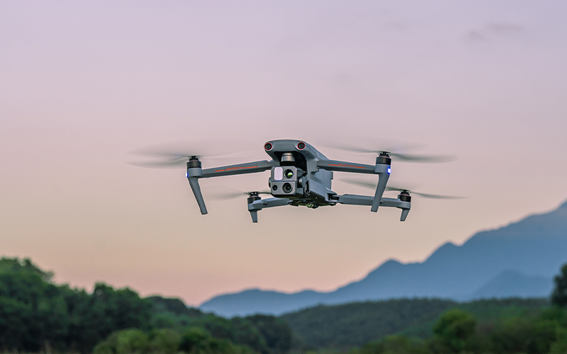
IP43 Weather Rating | Platform Capability
EVO Max 4T redefines portability with its powerful platform and all-weather design.
• 42 Minutes Maximum Flight Time
• IP43 Weather Rating
• 23,000 Feet Service Ceiling
• 12.4 Miles Image Transmission Range
• 27mph* Maximum Wind Resistance
*Takeoff and landing can withstand wind speeds up to 27mph
A-Mesh 1.0 | The Drone Industry’s First Mesh Networking Technology
EVO Max 4T features the new A-Mesh system, enabling drone-to-drone autonomous communication, connection, and collaboration.
• Strong Anti-interference: The EVO Max 4T can communicate seamlessly with other drones in the vicinity, unlike a traditional chain structure. If a single drone fails or exits unexpectedly, the entire system will independently self-organize and continue to relay critical information.
• Beyond-line-of-sight Applications: With A-Mesh, multiple aircrafts in the vicinity can act as relay points to greatly improve BVLOS operation effectiveness.
• Full-fleet Control: Multiple drones can be controlled autonomously by 1 pilot or by a group of pilots simultaneously with or without LTE coverage.
• Enhanced Range: Communication nodes can be placed statically on hills or poles to provide full coverage to an area, or a swarm of drones can provide mobile communication points to extend the coverage of the entire group.
Autel SkyLink 3.0
The EVO Max 4T SkyLink 3.0 system comes with 6 antennas, 4 frequency bands, AES-256 encryption*, and optional 4G integration* to provide users with the most advanced flight capabilities ever in an EVO.
• 12.4 Miles Image Transmission Distance
• <150ms Latency
• 1080p / 60fps Real-time Image Quality
• 900MHz / 2.4GHz / 5.2GHz / 5.8GHz** Frequency Bands
*This feature will be available in a future update
**5.2GHz is only applicable for FCC, CE, and UKCA regions. 900MHz is only applicable for FCC regions.
One-of-a-kind Fleet
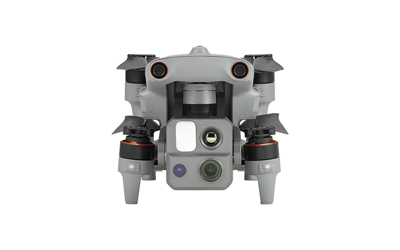
Mission Ready Payload
The payload integrates wide-angle camera, zoom camera, thermal camera, and a laser rangefinder for all data capture needs and critical decision making.
• 50MP Wide Camera
• 48MP Zoom Camera
• 8K 10x Optical Zoom
• 160x Maximum Hybrid Zoom
• 640 x 512 Thermal Resolution
Wide Camera | Moonlight Algorithm 2.0
Moonlight Algorithm 2.0 boosts post processing and allows the pilot to capture crisp, detailed images in low-light environments. Moonlight mode reduces noise and enhances HDR.
• 50MP
• 1/1.28″ CMOS
• Aperture: f/1.9
• DFVO: 85°
• Equivalent: 23mm
Zoom Camera | Clear details on targets up to 1.24 miles away
• 48MP
• 8K 10x Optical Zoom
• 160x Maximum Hybrid Zoom
• Aperture: f/2.8-f/4.8
Thermal Camera
• 640 x 512
• Aperture: 13mm
• 16x Digital Zoom
• Temperature Measurement
• Range: -20° to 550°C
Laser Rangefinder | Tap a target to get the coordinates and altitude rapidly from up to 0.75 miles away
• Measuring Range: 5 – 1200m
• Measurement Accuracy: +1m
Autel Enterprise App Platform
The Autel Enterprise App is built from the ground up for industrial applications and features a brand-new interface for simple, efficient operation. Additional features and semi-autonomous modes maximize the EVO Max 4T’s mission capability.
Smart Features
• 3D Mapping Planning: Plan, create, and execute 3D waypoint mission plan on a 3D map.
• Quick Mission*: Temporary quick missions can be created while executing other missions, and multiple sub-missions can be stacked for enhanced flexibility.
• Mission Reproduction*: With this feature activated, fly a manual or semi-autonomous mission, or string multiple missions together. The EVO Max 4T will automatically record the camera angles and replicate the mission you just flew.
* This feature will be available in a future update.
Multiple Mission Types
The Enterprise App provides various autonomous and semi-autonomous mission planning for public safety, inspection, and surveying.
• Terrain Follow*: Maintain relatively constant altitude from the ground for uneven or sloped terrain.
• Rectangular Mission: Supports one-click automatic generation of a rectangular flight area.
• Automatic Mission Generation and Data Capture*: Automatically produce routes by adding regional boundary points through dots or importing KML files.
• Waypoint Missions: Users can add waypoints for flexible, non-structured flight paths.
• Oblique Photography: Automatically plan 5 groups of routes (1 ortho + 4 oblique) according to the flight area set by the user.
• Spiral Mission*: Supports helical flight search in a designated area for SAR.
• Vertical Scan*: Perform vertical surveys for building facades, open pit walls, and towers.
• Corridor Mission*: Support intuitive and effective corridor mission planning for roads, rivers, pipelines, power lines, and other narrow, large-scale terrain.
• Polygon Mission: Supports one-click automatic generation of polygon flight areas.
* This feature will be available in a future update.
Data Security
• Privacy Protection: Data involving user and aircraft information, including flight logs, locations, and account information can only be physically accessed via the aircraft locally.
• Encrypted Data Storage: Supports AES-256 encryption for photos, videos, and flight logs, are password-protected.
Enhanced Live-view
• Multi-channel Projection Screen*: Supports simultaneous output of RGB, infrared, night vision, and wide-angle images.
• AR Scene*: Geo-location data and other aircraft location information detected by ADS-B can overlay on real-time map, which is convenient for users to confirm the drone’s location and avoid airborne risks.
* This feature will be available in a future update.
Autel SDK
The Autel SDK is open to the world, helping developers and partners reduce software and hardware development costs and jointly create a new industry ecosystem.
• Mobile SDK: Open UX SDK (iOS and Android) can directly call up the ready-made interactive interface.
• Payload SDK*: Unified interface standards support access to third-party mounts such as microphones and gas detectors.
• Cloud SDK*: Enables remote live broadcast and control of drones and Nests through third-party platforms or web pages.
* This feature will be available in a future update.
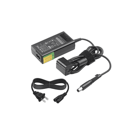
Accessories
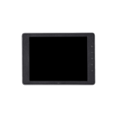
Autel Smart Controller V3
• Daylight Readable Display: 7.9 inches, 2000nit maximum brightness, 2048 x 1536 resolution.
• SuperDownload: Download footage from drone to mobile device at a maximum rate of 20MB/s.
• Functional Interface: HDMI ports allow connection to 3rd party displays or monitors.
• Ultra-long Battery Life: Up to 4.5 hours of continuous operation. 2 hour fast charging from empty.
• Local Storage: Built-in 128GB storage space allows 3rd party apps and mission media storage.
Live Deck 2 (optional)
• Broadcast live mission intel to other personnel in the operation for enhanced situational awareness and critical decision making without the need for LTE connection. The EVO Max 4T is compatible with Live Deck 2, which offers multiport streaming to monitors and Wi-Fi support for multiple local smart phones.
RTK Module (optional)
• Provides centimeter-accurate positioning data for mapping and reduces electromagnetic interference for flying near critical structures.
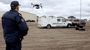
Applications
• Inspection
• Search & Rescue
• Public Safety
• Mapping
• Firefighting
Solutions
Frontier Precision provides world-class solutions for a wide variety of industries using leading products, training, technical services and more.
Products
Frontier Precision knows that every measurement its customers take is important. It’s why Frontier Precision not only offers the latest, cutting-edge measurement tools, but also understand the continuing need for service and support — because How You Measure Matters encompasses the total customer experience.
● Used & Clearance Equipment
● Rental Equipment
● Drones/UAS Aircraft
● Underwater ROV’s & Robots
● Survey
● Mapping & GIS
● Damage Prevention & Locating Devices
● Mosquito & Vector Control Software
● Invasive Plant Control Software
● Monitoring
● Scanning/Imaging
● Construction
● Augmented Reality
● Mixed Reality
● Forensics
● Water Resources
● Software
Technical Services
From Geospatial Services to GIS Professional Services to Water Resources Data Acquisition Services, Frontier Precision delivers leading-edge measurement technology. We’ve been there, every centimeter of the way, as geospatial technology has evolved. No matter what your need for accurate measurement, we have the experience and expertise to create a customized solution for you.
● Water Resources Data Acquisition Services
If you require customized technical services and training, please contact Frontier Precision at 800-359-3703 or reach out to a local Frontier Precision location.
Training and Events
From Geospatial Services to GIS Professional Services to Water Resources Data Acquisition Services, Frontier Precision delivers leading-edge measurement technology. We’ve been there, every centimeter of the way, as geospatial technology has evolved. No matter what your need for accurate measurement, we have the experience and expertise to create a customized solution for you.
- Technical Training & Events Calendar
- Technology Webinars
- Customized Training Request
- On-Demand Training
- Learning Lab
Frontier Precision offers affordable regularly scheduled certified training classes, online eLearning, webinars, as well as custom training options to meet your specific training needs.
Support
Frontier Precision provides world-class support from centers across a wide section of the western United States. Need support for any geospatial products, software or services?
Contact Frontier Precision at 800-359-3703.
About Frontier Precision
Frontier Precision’s measure of excellence can be traced back to 1988. Four years later, in 1991, Frontier Precision partnered with Trimble — a United States-based GPS equipment manufacturer at the time, and the rest is history. Since then, Frontier Precision has grown with Trimble to be one their largest and best geospatial distributors in the world.
We’ve been at the frontier of technology for three decades, continually offering customers new tools and solutions, all with our end goal in mind to help make our customers efficient, productive, and profitable with today’s and tomorrow’s technology. Frontier Precision is an employee-owned company — each of our team members is committed to your success.
Contact Frontier Precision
WHEREVER YOU ARE, WE ARE.
From our original office in Bismarck, North Dakota, we’ve grown our footprint thousands of miles in every direction.Today, you’ll also find us in South Dakota, Minnesota, Colorado, Alaska, Montana, Idaho, Hawaii, Wyoming, Oregon and Washington — delivering the Frontier Precision difference to more people each day.