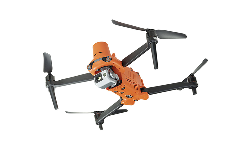
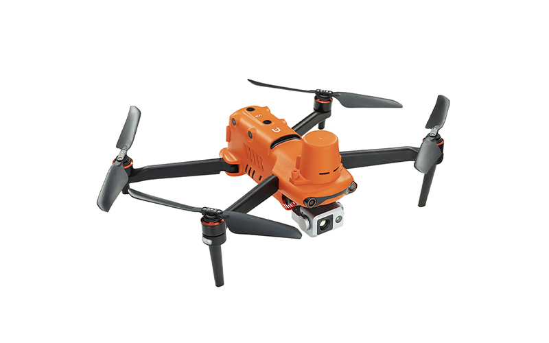
Description
Dual Cameras and Accurate Temperature Measurement
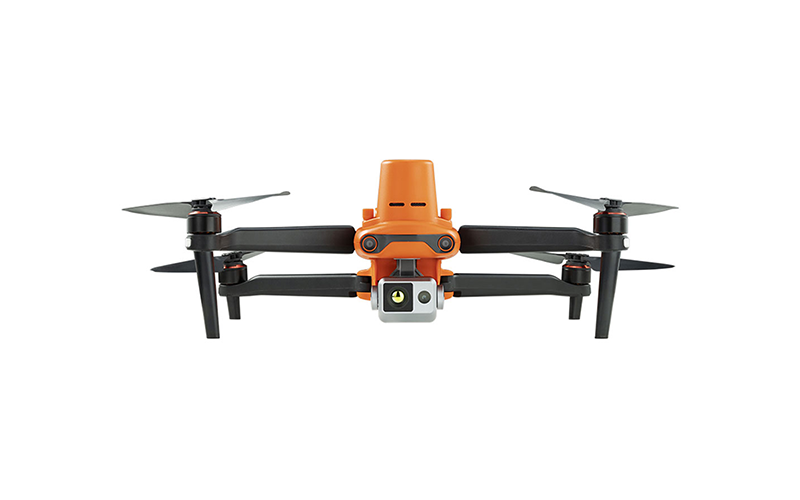
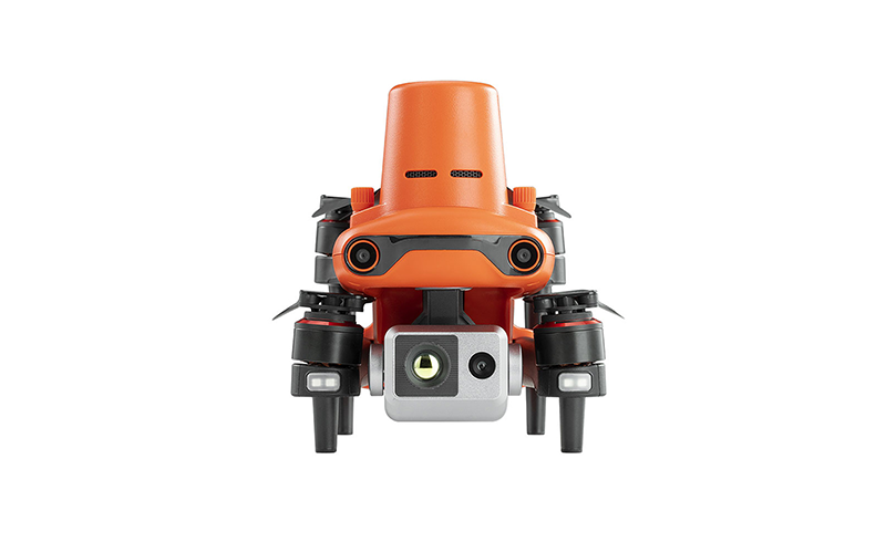
The EVO II Dual 640T RTK V3 is equipped with a high-resolution thermal imaging camera and an all new Sony .8″ 50 megapixel RYYB sensor.
High-resolution Thermal Imaging Sensor
Equipped with a 640 x 512 high-resolution thermal imaging camera featuring a 13mm focal length lens and 16x digital zoom, it is easy to observe distant targets. The system uses a new image processing algorithm, making thermal imaging details clearer and more discernible than the competition with similar resolution and hardware.
Precise Temperature Measurement
The EVO II Dual 640T RTK V3 can accurately detect heat sources within a distance of 2-20 meters. By leveraging the compensation algorithm of infrared temperature measurement, the 640T RTK can regulate temperature deviations within 3°C.
New Image Processing Algorithm
The V3 system uses a brand new image processing algorithm making thermal imaging details sharper and more discernible than competitors with similar resolution and hardware.
30hz Refresh Rate for Videogrammetry
The EVO II Dual 640T RTK V2 provides high refresh rates for accurate and detailed 3D thermal maps.
Zoom In for the Details
Focus in on critical areas with the EVO II RTK V3’s 4x lossless zoom and 16x digital zoom.
Multiple Color Palettes
White Hot; Cold and Hot; Rainbow; Enhanced Rainbow; Iron Bow; Lava; Artic; Searing; Gradation; Heat Detection
More Applications for 640T Thermal Drones
Thermal Drones in Wildlife Management
More than 6 million feral hogs roam the US. From Hawaii to Florida, these invasive cousins of domestic swine have increased their range from 17 states in the 1980s to more than 35 states today. Able to breed year-round, with average litters of five to eight piglets, feral hog populations can double in size within four months. Weighing between 75 and 500lbs, feral hogs’ aggressive behavior is very destructive to agriculture, natural ecosystems, people, pets, and livestock.
Thermal imaging helps spot predators that could injure or kill farm animals. This will ensure peace of mind for farm owners.
Thermal Drones in Hunting
Using drones to hunt wild hogs is an excellent use case. Add a thermal camera and they are easier to spot. Using drones to hunt hogs has been a common practice for many years, but it used to be extremely expensive. Hunters in the past used $15k+ rigs to make it happen.
Now drones with thermal cameras are cheaper than ever – and extremely easy to fly.
Thermal Drones in Residential Roof Inspection
On shingle, tile, or slate roof structures, you can document the exterior condition of the roof using UAV-based high-resolution imaging where we can easily observe hail damage, wind damage, openings in the roof, cracked tiles, and much more. When it gets wet, it creates a hotter temperature on the surface of the membrane that can be easily detected with infrared imaging.
Low Sloped | Flat Roof Scans
You can identify moisture in commercial roofs using the EVO II Dual 640T Thermal drone, confirm moisture with further physical testing, and process a detailed report that calculates how much of the roof contains moisture.
Shingle | Tile | Slate Roof Surveys
Using drones with high-resolution cameras, you can capture detailed images observing hail damage, wind damage, broken or missing shingles or tiles, and more, processing detailed reports.
Thermal Drones in Industrial Inspection
The EVO II 640T uses an 8K Visual Spectrum Sensor and 640 Radiometric Thermal Sensor, giving inspectors the ability to perform multiple roof inspections in half the time it takes by conventional methods. Our drone kits will not only allow you to visually inspect the entire building, but also use thermal technology to check for hot spots. This enables you to safely and quickly check the status of the structure, as well as identify defects, leakage, and corrosion issues without having to spend on additional personnel and equipment.
Thermal Drones in Agriculture
The benefits of drones in agriculture have been well documented, but beyond monitoring crop and plant health, drones can also keep track of livestock with thermal cameras. In flight, a drone with thermal imaging capabilities is a powerful tool for monitoring many different types of wildlife. Thermal cameras can detect the heat signature from an animal at a distance, providing drone pilots with data they otherwise wouldn’t be able to gather.
Thermal Imaging Function
• Picture-in-picture Mode: visual and thermal imagery are combined to help users quickly interpret data and critical decision making. From top to bottom are “Picture-in-picture Mode”, “Infrared Mode”, and “Visible Light Mode”.
• Spot Temperature Measurement: tap the screen and the temperature of the selected object will be displayed in real time.
• Regional Temperature Measurement: get a dynamic view of the average temperature, maximum temperature, and minimum temperature displayed in a selected area. The temperature frame can be dragged to any position on the screen.
• Temperature Warning: monitors the screen temperature in real time. The system prompts the user when the temperature reaches a set threshold. Note: The temperature alarm takes effect only in Regional Temperature Mode
• Image Enhancement: supports real-time adjustment of image brightness, contrast, and image details. The system will highlight any objects within the temperature target.
• 10 Thermal Color Palettes: White Hot; Cold and Hot; Rainbow; Enhanced Rainbow; Iron Bow; Lava; Artic; Searing; Gradation; Heat Detection
• 4x Lossless Zoom
• Human Search
Powerful Infrared Thermal Analysis Tool (IRPC)
This free temperature measurement analysis tool is developed for the 640T and enables users to quickly import images, edit and analyze temperature measurement, and to generate detailed reports for sharing and collaboration. (Select the “Word” icon Export report. Generate analysis report)
All three camera modules support a variety of shooting modes including: Single-shot, Burst Shooting, Auto Exposure Bracketing (AEB), Time Lapse, High-dynamic Range (HDR) imaging, NIGHTBEAT (high signal-to-signal ratio)
Connect Autel Live Deck to Display Live on Any Device
A high-definition live feed from the EVO II drone camera can be displayed on your remote control’s screen or connect with Autel Live Deck to be displayed on any device including computer, phone, TV, etc. Of course, images and videos can be stored in the aircraft’s onboard memory or on a micro SD card.
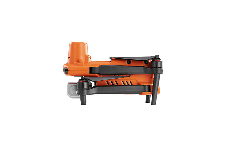
Adjust Field-of-view to Any Angle from 0° to 90° While Flying
The EVO II Dual drone contains a high-precision 3-axis gimbal that keeps the camera steady while the aircraft is flying, ensuring image stability and clarity. Also, you can use the remote control’s gimbal pitch dial to adjust the pitch axis to any angle from 0° to 90°.
All Cameras are Interchangeable
The Autel EVO II Series drone is one aircraft with three camera options. All cameras for the EVO II can be purchased separately and are interchangeable.
Autel EVO II Dual 640T RTK Module
Centimeter-level Positioning System
The EVO II RTK Series integrates an entirely new RTK module, which provides real-time centimeter-level positioning data and supports Post-Processing Kinematic (PPK). The EVO II RTK aircraft can record the original satellite observation data, camera exposure parameters and various other data. The positioning system supports A-RTK base station and RTK network, which helps to achieve accurate and stable data acquisition in complex operation environments.
• Centimeter-level, high-precision positioning system
• No need for ground control points
• Omnidirectional obstacle avoidance
• A-RTK base station
Mission Execution with Advanced Intelligence
The EVO II RTK Series aircraft offers users a full range of intelligent features and solutions to suit a variety of mission needs. Using advanced flight control and the latest AI technology, the aircraft can significantly improve mission work flows and help reduce operating costs.
Creating Mission, Waypoint Flying, 720° Omnidirectional Sensing & Obstacle Avoidance, Photo Replication, No Need for Ground Control Points, High Precision RTK / PPK Positioning, Support A-RTK High Precision GNSS Base Station.
After creating a flight route, the EVO II RTK can fly on the designated flight path autonomously, enabling a smoother, more efficient flight.
No Need for Ground Control Points
The EVO II RTK Series leverages a high precision RTK module, supports PPK and time synchronization, and is not limited by communication links or network coverage.
• RTK / PPK: supports third party base stations with NTRIP capability
• RTK High Precision GNSS Base Station: supports RTK high-precision GNSS base station to obtain real-time differential data, which makes it possible to obtain the accurate coordinates of the designated target point.
AI Enhanced Dynamic Track
The EVO II Dual smart tracking uses deep learning algorithms to automatically track the selected subject while avoiding obstacles during flight. The function can track the subject in three modes: behind, side-by-side, or fixed position.
360° Obstacle Avoidance
The EVO II Dual’s front, rear, left, right, top, and bottom binocular vision sensing systems use image data to calculate the distance between aircraft and potential obstacles. It begins detecting potential hazards up to 30m away and accurately controls the speed of the drone to avoid a collision.
• 12 optical sensors + 2 sonar sensors
Viewpoint
Viewpoint allows the user to send the aircraft to a selected destination by touching a point on the screen. Featured with the same waypoints function as the EVO to program autonomous flight routes. The EVO II Dual can even save multiple waypoint missions making it easy for surveying.
Auto Go Home and Accurate Landing
The EVO II Dual will return home automatically when it reaches low battery level or communication is lost. Additionally, the EVO II’s bottom binocular vision camera can be used to create a density depth map. Then, it calculates the depth map’s flatness and angles to ensure an accurate and safe landing.
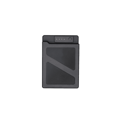
Super Battery Life and 9km Extended Range
The Autel EVO II comes standard with a 7100mAh rechargeable battery, providing up to 38 minutes of flight time in forward motion up to 9km away – and 35 minutes at a hover. The EVO II has a top speed of 45mph. There is no geofencing or cellular service restrictions on any of the EVO II Duals.
Autel SkyLink 2.0 Video Transmission
SkyLink 2.0 is built into the EVO II Dual 640T V3 chipset, expanding the possibilities for your most critical workflows.
• 9+ Miles | Do more because you can fly further away
• QHD | Incredible video resolution within a mile, meeting most common use cases
• 2.4GHz / 5.8GHZ / 900MHz | Supports tri-band communication with automatic frequency hopping for maximum anti-interference capabilities (900MHz is only applicable for FCC countries)
Autel Smart Controller SE
The Smart Controller SE comes with a 6.4-inch OLED touch screen and latest gen. 8-core processor for HD image transmission. SkyLink 2.9 Transmission technology guarantees long-distance operations from up to 15km away and enhances anti-interference abilities with tri-band frequency hopping. The customized Android system allows for additional flexibility with third party apps and an IP43 rating ensures all weather performance.
• 6.4-inch OLED Screen
• 15km Transmission Range
• Removable Battery
• 3rd Party Apps
• -10° to 40°C Operating Temperatures
Solutions
Frontier Precision provides world-class solutions for a wide variety of industries using leading products, training, technical services and more.
Products
Frontier Precision knows that every measurement its customers take is important. It’s why Frontier Precision not only offers the latest, cutting-edge measurement tools, but also understand the continuing need for service and support — because How You Measure Matters encompasses the total customer experience.
● Used & Clearance Equipment
● Rental Equipment
● Drones/UAS Aircraft
● Underwater ROV’s & Robots
● Survey
● Mapping & GIS
● Damage Prevention & Locating Devices
● Mosquito & Vector Control Software
● Invasive Plant Control Software
● Monitoring
● Scanning/Imaging
● Construction
● Augmented Reality
● Mixed Reality
● Forensics
● Water Resources
● Software
Technical Services
From Geospatial Services to GIS Professional Services to Water Resources Data Acquisition Services, Frontier Precision delivers leading-edge measurement technology. We’ve been there, every centimeter of the way, as geospatial technology has evolved. No matter what your need for accurate measurement, we have the experience and expertise to create a customized solution for you.
● Water Resources Data Acquisition Services
If you require customized technical services and training, please contact Frontier Precision at 800-359-3703 or reach out to a local Frontier Precision location.
Training and Events
From Geospatial Services to GIS Professional Services to Water Resources Data Acquisition Services, Frontier Precision delivers leading-edge measurement technology. We’ve been there, every centimeter of the way, as geospatial technology has evolved. No matter what your need for accurate measurement, we have the experience and expertise to create a customized solution for you.
- Technical Training & Events Calendar
- Technology Webinars
- Customized Training Request
- On-Demand Training
- Learning Lab
Frontier Precision offers affordable regularly scheduled certified training classes, online eLearning, webinars, as well as custom training options to meet your specific training needs.
Support
Frontier Precision provides world-class support from centers across a wide section of the western United States. Need support for any geospatial products, software or services?
Contact Frontier Precision at 800-359-3703.
About Frontier Precision
Frontier Precision’s measure of excellence can be traced back to 1988. Four years later, in 1991, Frontier Precision partnered with Trimble — a United States-based GPS equipment manufacturer at the time, and the rest is history. Since then, Frontier Precision has grown with Trimble to be one their largest and best geospatial distributors in the world.
We’ve been at the frontier of technology for three decades, continually offering customers new tools and solutions, all with our end goal in mind to help make our customers efficient, productive, and profitable with today’s and tomorrow’s technology. Frontier Precision is an employee-owned company — each of our team members is committed to your success.
Contact Frontier Precision
WHEREVER YOU ARE, WE ARE.
From our original office in Bismarck, North Dakota, we’ve grown our footprint thousands of miles in every direction.Today, you’ll also find us in South Dakota, Minnesota, Colorado, Alaska, Montana, Idaho, Hawaii, Wyoming, Oregon and Washington — delivering the Frontier Precision difference to more people each day.